Saturday, April 30, 2011

Allegany State Park - Part II - Fun Times on Mt. Tuscarora

After chasing bears early this morning, I returned to my vehicle and set my sights on the great Mt. Tuscarora.  Truth be told, there are many "mountains" in Allegany State Park - and of which - I've actually visited the peaks of a couple of them.  For example:
I've also had the pleasure of hiking other trails in ASP which made their way up, around and about other glorious hills.  There are probably a dozen other hills that I haven't summited, but I'm sure at some point I'll get around to them.  I'm just pacing myself - those things are crazy high!  Haha.

The purpose of my visit to ASP today was to find the second installment of Mt. Tuscarora by HeadMJ.  I had been fortunate enough to find the original Mt. Tuscy during the epic hiking summer of 2007.  You see, at that time a strange cacher named Cayuga Crew decided to hike the length of the Conservation Trail which runs from Niagara Falls, NY all the way down through ASP and the Pennsylvania border.  This was a pretty ambitions endeavor, and at some point emails were traded, and Chicky and I went from delivering Timbits roadside to support this wayward hiker to inhaling his exhaust as we hiked alongside him.  Through this process I developed a friendship with him, to the point we became close (or as chummy as you get with a guy who baits you up hills with processed meat snacks and cheeses while lying to you by saying the rest of the hike is "all down hill").  Now that I think of it, Cayuga is one smarmy son-of-a-bitch. But that's not part of the story...well it is I guess.  You see, towards the end of this months long hike, the only thing standing in our way from crossing the PA border and completing this grand adventure was Mt. Tuscarora. 

Mt. Tuscy takes no prisoners, and while the hiking was amazing, this was one of the more difficult hikes to accomplish due to the terrain and the distance.  Of course because you can't say no to Cayuga (especially when he's your ride back to the car which is parked miles and miles and miles away), we made a mile round trip side hike to the top of old Mt. Tuscy to find the cache and enjoy the old abandoned fire tower that sits at it's peak.  That would be our last cache find before crossing over into PA!  It was also my first (and before today, last) visit here. 

Since then the original has been archived, and version 2.0 has taken it's place...which in turn was about to be archived itself!  So I had to make the hike back up the hill and subsequently be the last to find this cache, before making way for V.3.0.

There are several different ways to approach this cache.  Basically it runs the gamut from steep to stupid ridiculous steep.  Topo lines abound and to short cut may require scrambling on all fours in sections.  My preferred plan of approach in these scenarios is a long hike with a more gradual incline.  Of course, in this instance the hike would be about 5.75 miles (round trip) and an elevation change of over 550 feet.  That's a lot of topo lines to cross!  I figured if I was going to send off Mt. Tuscy, I was doing to do it in style - so at 9:30 am my feet hit the trailhead at the bottom of the mountain and up up up I went!


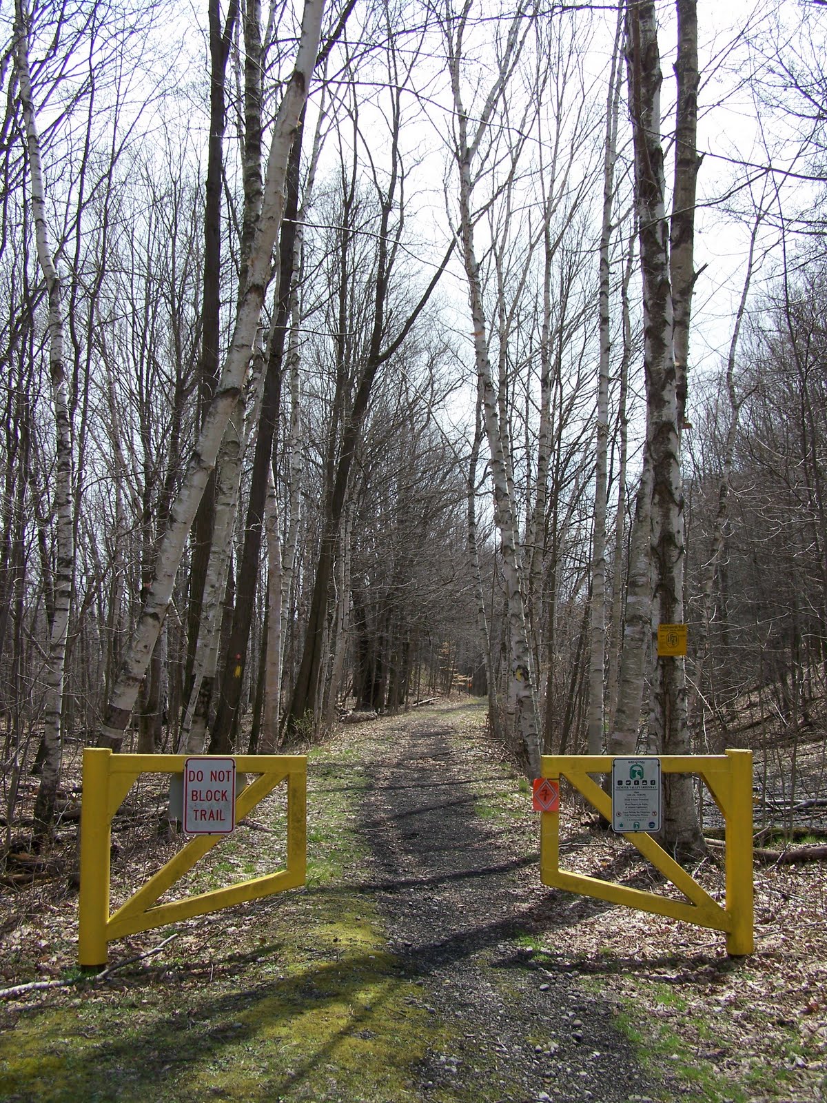
Here's my trailhead...and seeing as there are no bodies laying at the foot of this mountain, I was encouraged to continue on upwards to the top of the hill.  I was pretty excited to hike this trail, as 90% of it was going to be new to me until I hit the top of the ridge and pickedup the North Country Trail which I had hiked on my first visit here in 2007.


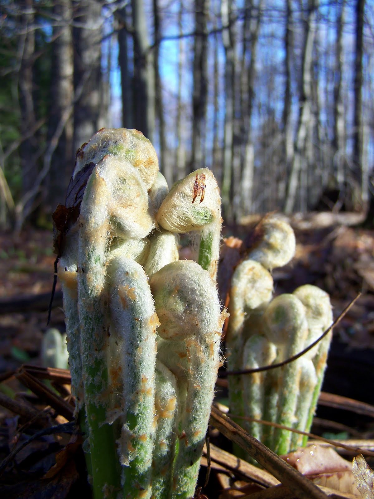
Luckily for me lunch was served...because everywhere along the trail were delicious leeks!  They have a sort of onion-esque taste and are great right out of the ground.  The first mile of trail was absolutely carpeted with them - so of course I had to nibble on a few...my mountain man survival skills rock!  LOL.


Who doesn't love spring right?  The wildflowers were everywhere, and you couldn't go two steps without a smattering of color lining the trailside.  These little pretties were located along the ridge on the way to the summit.  In need of a break, I plopped right down on the ground and started snapping photos. That's how you multitask on a trailbreak!


I thought getting to the ridge was the hard part...what I forgot is after the big hill...you get a nice level walk for a quarter mile, and then another half mile up hill to the tower!  I smiled when I saw the sign pointing "up"...bring it on baby!


Hellooooooooooooooooooooo big killer sweet abandoned fire tower in the middle of the woods!  As you crest the hill the remnants of the fire tower start to peek through the bare trees.  It's pretty neat to see this huge structure - still mostly intact after being "returned to the woods" around 1970.  I had to snoop around a little bit and take some pictures.  I eventually covered the remaining 250 feet to the cache and quickly I made the find.  Hoooooooray!  Of course that was only half of it - the real treat was the view of Quaker Lake way down in the valley.


I probably loitered a good 20 minutes or so, looking at the original logbook, smiling as I read about my last visit here where we touted that we "thru-hiked in from Niagara Falls to do this cache."  Ahh...fond memories.  Eventually I rehid the cache, and started the long hike back.  I made many stops on my return trip, just because I was exhausted and the sun was now pretty warm.  So being the every busy "hiker at rest," I took more pictures!


The ridge in the background of this one is actually where the North Country Trail is...and I was only a hundred feet or so where the Mt. Tuscy and NCT meet.  I had to pit stop on my decline to get a picture of these flowers as they basked in the afternoon sun.


This trail was pretty remote, and with the exception of one other person at the very very end, I had it completely to myself.  Even at the tower.  It was exceptional and I really couldn't imagine a better day for such an expedition.


Who doesn't love a trail lined with hardwoods that heads downhill?!?  What a great experience - I'm glad I pushed myself to complete this cache...and guess what...the next day, Mt. Tuscarora III went live.  I'll give the legs a little while to rest before climbing that big fella again!

Allegany State Park - Part I - Bear Man Pig...?

This particular blog starts sometime earlier this week when I was fluttering about the cache pages looking for a wonderful adventure to tackle this weekend. It was then that became aware that a superb cache in Allegany State Park was slated for demise. ASP is a really cool place - and probably my second favorite NYS park behind Letchworth. It covers 65,000 acres of insane mountainous woodlands, and comes with a variety of touristy destinations.

That being said, the cache unto which caught my eye was Mt. Tuscarora by HeadMJ (AKA: Mike). Mike is a regular contributor to the caching scene in ASP, and without sounding too snobby, is probably the best cache-placer the park has. I say this because he places caches that appeal to me - in that - they are located far into the woods away from the other P&G caches in the park (which isn’t to say those are “bad”…but they just aren’t of HeadMJ ilk…haha). Anyway, Mt. Tuscy was placed in 2009, and since I was incapacitated during the vast majority of it’s existence, I didn’t want to see Tuscy V.2.0 pass by without me finding it. You see, caches in NYS parks have a two year lifespan (uh…well…generally…haha), so in Mike’s instance, when the two years is up, he archives his cache and replaces it with a new version. It’s the same hike to the same general area, it’s just a “new” cache to find.

Blah blah blah Eric, just get to the dang point.”

Well my foul-mouthed readers, the fact that this cache was going to be archived necessitated the trip down south to play in the woods of ASP. I wanted to be the last to find on this cache, and after trading some emails with Mike, it was decidd that the cache would still be available for my grubby mitts on Saturday. An added bonus to this, was two new HeadMJ caches were just released in the Park. One of them was along my route to Mt. Tuscy!

I was out the door early, and made the nice sunny A.M. jaunt down to Bradford, PA. From there I entered the southern side of ASP. The first stop on my journey would be Wild Pig by HeadMJ. This was the new cache posted a couple days earlier - and I figured a nice short hike would be a good warm up before I played king of the mountain. However, when I parked, I realized quite quickly that I underestimated the length of this “short hike.” In total, it was going to be about a mile and half round trip. I decided that if I was going to do it, I was going to do it right. So down the trail I headed.


This was a pretty cool trail actually, because it went just this side of the NY/PA border.  The cache itself is only about 600 feet from the border - so it's neat to think that you're in the middle of the woods and without knowing it you could be crossing state lines.  Not to give anyone any ideas or anything...haha.


The hike in was beautiful, as the air was super crisp and the sun had just crested the tree tops.  It was the perfect day to be outdoors.  I continued down the trail until I knew I had to dive into the woods to cover the rest of the distance to the cache.  It was a mostly open walk - although it's pretty hard to bushwhack through the woods without getting hit in the face with a beech sappling.  The damn things just jump right out in front of ya!  Anyway, after getting smacked around like Mother Nature's beeyotch, I arrived at the cache location and quickly found the prize.  I signed in - and of course took a picture.


That's what a real cache looks like folks - haha.  After I performed my rehiding duties, I made my way out of the woods, returning to my happy little sunshiney trail.  I was hardly back on the trail when I saw the most awesomest thing EVER!


That's right...check out those kick ass ferns!  I probably spent a good 15 minutes photogogging these beauties using the one or two techniques my camera is actually capable of doing.  If I knew I was going to capture them unrolling and springing into fern formation you'd probably be watching a video right now...but I digress.  After documenting the ferns adorable existence...I then found something of equal or greater value as measured on a scale of awesomestness!!!


It's my hand...sweet huh?  Oh yeah, and that thing next to my hand is a bear paw print!  Holy flapjacks Batman!?!  Probably within an hour or so of me being on this trail, a black bear went meandering through and left his paw print in some mud.  I was giddy...like...16 year old prom girl giddy.  Just be glad your reading about it, because if you would have witnessed it, I don't think we'd ever get over the uncomfortable silence. Hahaha.

This was a first for me actually.  I don't think I've ever found evidence of a bear being near me like this before - so of course now I was scouring the woods to see if I could capture a glimpse of this cuddly fuzz ball.  Alas, my lover-bear was no where to be found - but on the bright side he did leave me this:


Classy right?

Sunday, April 24, 2011

My new cache: A fun little update 'cause I'm a dork.

After P-Man and BFG accidentially did one mile of additional "not on the original agenda hiking" in the wrong direction, they were finally able to get themselves turned around and I'm glad to report they found the cache (which what sounds like no additional complications...haha).

For those curious, here is P-Man's log (with pictures) and also ButterflyGuy's!

Congratulations on completing this adventure, even after doing an additional (and unexpected) mile on trails that I know where really wet and muddy!

The Great Letchworth Adventure!

Last weekend I finished my cache (AKA: The Hike) in Letchworth State Park - and once it was all set in place I decided to let it cure until the following Friday.  I was really happy when it went live.  It's been a while coming, but it was finally out in the cosmos for mass consumption.  So knowing that there might be people looking to find this shiny new adventure, Chicky and I decided to spend the day caching/hiking in the park.  There are a few caches I wanted to work on, and at the same time I thought it would be neat to loiter in the area and see who might be brave enough to tackle this one. 

The morning started off a little precarious, as WNY was getting hammered with monsoon like rains.  Reports indicated that the storms would move out of the area by mid-morning, so we decided to start the morning off by snagging a little breakfast at the Eagle Inn, located in the cow-filled metropolis of Eagle, New York.  Haha.  From there we watched the rain pour and pour, but it must have been Mother Nature's last hurrah, because after that the hardest of the rain let up.

From there we were free to travel to Letchworth under cloudy and mostly dry skies.  The first stop was to cruise by the parking locations for my cache.  The Hike recommends parking in two different locations, one to start your journey and one to end your journey (there's about 2.5 miles of road between the start and end points of the cache).  Anyway, there were a few cars littered about on this side of the park - in what would turn out to be hunters actually (I have no clue what season is open right now...probably something bizarre). 

None of the vehicles looked familiar, so we headed into the park to start a cache called 20,000 Meters Under the Cache by MysterySolvers6.  I wish I could tell you what that means...but all I can figure is it's a play on words, from 20,000 Leagues Under the Sea by french novelist Jules Verne (who in his Wiki picture looks like a happy fella).  As far as I know, whales are not indigenous to mainland Western New York, and I'm pretty sure park management would be awful sore if you went tearing along the Genesee River in a submarine.  Not that I wouldn't consider it.  But I digress...

The cache is a 5-part multi, so it takes you to many different spots on your way to your final destination.  With the sun started to finally peek through the clouds, we parked near the first stage at Inspiration Point and started our journey.  While Chicky looked for the cache, I took pictures. 
 

Pretty sweet huh?

From there we made several other stops in order to complete the necessary requirements and find the final cache.  Because I don't want to give all the fun away, I will just shut up and post a few pictures for you to oooh and aww over.

The flowers are starting to bloom - yay!

The Lower Falls were raging really hard today.

Heading back down the trail.

No worries, there's like 18 more miles to go.  Haha.
In the end we got in a few miles of beautiful trail and scenery - in many places I haven't visited in years.  The longer we hiked, the nicer the day got.  By early afternoon, the sun was out and there were beautiful blue skies. This was the perfect day to be in Letchworth! 

At some point in the morning, while in between legs, we got a call from Paleoman and Butterflyguy.  They were working on my new cache!  I was pretty excited to hear from them, until they told me they had made a wrong turn somewhere.  After trying to figure out where exactly they were, we determined they had overshot a turn in the trail and were going to have to backtrack.  To provide a little guidance, Chicky and I headed over to the other side of the park and quickly made our way down the Bear Meadow access trail to where it met with the Finger Lakes Trail.  Just as we were approaching, I saw them crossing a gully just ahead.  I shouted out to them, and soon we were chatting about their already thrilling morning adventure!  After making sure they had all the necessary information, we parted ways - us back to the truck and them on to the rest of my cache.  I was pretty excited that there were people tackling it, even on a day as wet and muddy as this. 

Please someone might very well find the cache today, Chicky and I returned to our own caching adventure.  On our way back to conclude 20,000 Meters Under the Cache we made a pit stop at the Parade Grounds in Letchworth to find another cache I had started previously called Civil War Connections in LSP by Dehgewanus.  This is a puzzle/multi that explores the wealth of Civil War-related history that is present in the park.  Again, I don't want to give too much away - so here we go with a few pictures!!!

A biggun under the blue skies!

Chicky holding up the prize loud and proud!

Heading down the FLT under the sun - that's the way we rolllllllll.
After we were done playing on this particular section of FLT we went on to complete the rest of our geo-adventures - which actually required us to take a circuitous route to one leg where we ran into more cachers!  This time Howie and Jan were driving down the park road on the east side of the park - and happened to see us returning back to our truck.  It was really nice seeing them, and after chatting for a bit about the "geo-scene" we went our separate ways.  

Chicky and I eventually ended our day in Letchworth.  We had a blast playing in the park today, especially with the added bonus of seeing so many familiar friendly faces.  To celebrate the great hikes, good caches and fun times, we hit Carneys Market in Castile, NY for pizza slices and drinks.  It was delicious - and the perfect way to round out this Saturday outside.  In total, I ended up driving well over 100 miles in and around Letchworth - seeing so many beautiful sights.  I love this place - and I can't wait to return!

Monday, April 18, 2011

The Hike: A Resplendent Peregrination (AKA: An Expedition into Paradise)

Yesterday morning I looked outside. It was really windy (40 mph gusts) and it looked like rain and/or snow. But I had an itch I just had to scratch. A couple days previous, I got my shiny new Letchworth State Park Geocaching Permit, and it was burning a hole in my pocket. I couldn't let a little adverse weather talk me out of finishing what I had started. It was time to make "The Hike."

Since I started mapping out my geocache on the east side of Letchworth, I had piece mealed portions of the trail as I sought to find appropriate stages for the cache. I had yet to walk out the entire cache from start to finish, as I would intend it to be done once finalized.

I was a little intimidated by this, because there was a particular section of trail that from a length perspective was completely unknown to me. I had estimated it was about 2.25 miles - but it was just a guess based on Letchworth trail maps. In total, my guesstimated hike was clocking in at around 8.25 miles. That’s a long haul. I felt I could do it, but the year is still early and I’m not exactly in tip-top hiking form. So this would be the first time this year (and probably in a few years) that I’ve attempted a hike of this distance.  I was inspired though.  That’s a huge success in and of itself.

I suppose it's time to explain something.  There were a few sources that inspired me to not only blog about my hikes and share my adventures, but also to put together a thru-hike cache like this.

One was Dad.

Another was Cayuga Crew. In September 2007, Cayuga Crew thru-hiked the Conservation Trail.  This is a 177 mile hike from the Canada down to the New York/Pennsylvania Border.  This is a tough trail full of hills and other challenging terrain.  I hiked parts of this with Cayuga in blazing heat and monsoon like weather.  With his spirit and drive, he made it seem almost too easy (especially dragging my ass uphills!)  I remember coming home after a 10 to 12-mile hike in so much pain I could barely go to work the next day.  But I was so proud of myself, that I wouldn't miss a chance to be alongside him on the trail.

Another was the Green Tortuga (AKA Ryan Carpenter).  Ryan is the owner/operator/all knowing grand puba of Atlas Quest - "the" letterboxing website (sure there are others, but this is the best one...haha).  In 2010, Mr. Carpenter hiked 2,650 miles along the Pacific Crest Trail that runs from Mexico to Canada.  That's a hell of a long walk.  While he did that, he blogged about his adventures daily.  That takes serious dedication.  The more I read about his adventures, the more I wanted to have some of my own (although not nearly on such a grand scale!)  So that was part of the reason I started this blog.  :)

Finally, the last person who had a hand in all this mess is Sam Gardner.  This ambitious little critter, got the idea to hike the major trails in the United States back to back - which all told would be over 12,500 miles of thru hiking.  Mr. Gardner started on the North Country Trail.  Unfortunately he only accomplished half of this trail before being knocked off it due to health issues.  Regardless, I found a lot of enjoyment from reading about his progress via his blog. 

So that brings me back to Dad.  Dad passed away in July 2009.  For well over a year I was about as lost as a person could be.  I lost interest in everything.  I really thought I'd never have ambition, desire or drive again.  Only in the last 5 to 6 months did I start to really miss things I used to enjoy doing.  And when I decided to do this...that was a huge step.  I knew it wasn't going to be easy, but I wanted to focus my energy on something and make it happen.  Truthfully there's a lot I want to do, and this is only a small piece...but it's a start.  Anyway....as I stared outside into the cold, I felt confident.  I also felt worried. Worried that I would wuss out and put this cache off another day.  But the more I thought about it, the more I knew I had to do it.  It was personal. It was a challenge I wanted to overcome.  I wanted to do it for me.  I wanted to do it for Dad. The last two years nearly saw me destroyed…so to do this after the hell I’ve been though…I needed this. I needed to scratch one into the “W” column.

So it was decided.  It was time for "The Hike."  Lucky for me, I was able to arrange a ride from Brogan to pick me up when I finished.  That would save me a 2.5 road walk back to where I parked.  With that, everything was set.  I was headed for Letchworth.

I arrived at the parking a little before noon, and meticulously made sure I had everything I needed.  Water, GPS, maps, camera, granola bars....after checking and double checking, I was ready.  So I started down the Bear Hollow access trail towards the FLT.  It was a pretty crazy moment - no turning back!  Ironically, the hiking stick I had used last weekend when I was here was still propped up against the trail sign.  I took that as a good sign and snagged it to accompany me once again.  The early going was a mess.  The trail was wall to wall slop, and I probably wasn't 500 feet into my hike before my shoes and socks were muddy, wet and cold.  At least I had my hiking stick right?!?  Haha.


My gear relaxing trailside!

Eventually I was on the FLT hiking south.  The going was a little slow, just because my legs were still tired from Friday's hike.  I gave them a pep talk, and after 1.5 miles they finally started to warm up to the idea of hiking.  The weather was sketchy all day, and at this point the clouds were gray and gloomy.  It wasn't until about 2 miles in that I could hear any kind of precipitation - but at this point it was pretty light.  The first portion of the hike was done - and I had placed my first leg.  I was pleased with myself - I was one-third done!  (Eye roll...haha).  Soon I arrived at the onset of the mystery section of FLT.  I had no clue how long this section would be, but I was pretty determined and I thinking about it now, there was no hesitation.  I dove right in.  This section ended up being gorgeous.  It was also where I nearly ran a trail runner off into the gorge because neither of us were paying any attention.  As hiking hazards go, that's a new one to me!

A view from the "mystery trail."
In told, this section of trail would be about 1.5 miles.  Not nearly as long as I estimated - which was refreshing.  Unfortunately, with that refreshing news came a steady driving rain powered by 20 to 30 mph winds.  This was extremely frustrating...and also VERY cold!  I wore shorts for this hike, anticipating that as I went, I'd warm up to the point where pants would be too much.  In this junk, a windbreaker would have been kick ass!  In the pouring rain I hid the second part of my cache.  I also gave Mother Nature a verbal lashing about her poor choice in weather.  I was just a poor thru-hiker, show a little compassion!
The "what gives Mother Nature?!?!" look.
AKA: My Dangerfield impression.  Haha.
Wouldn't you know, about another half mile down the trail the sun poked out from behind the clouds, the rain stopped, and for the rest of my trek I was treated to sun and blue skies.  Big Mama N must like my style baby.  Haha.  I continued on - and somewhere around the 5 mile mark I realized I had caught a second wind.  I felt really good - and even though the trail was muddy, and navigating around the goo was a challenge, I was making exceptional progress.
A pretty spot to take a break...somewhere around mile 5 I think.
Soon I had arrived at the final for my cache - which was HUGE.  I was well over three-quarters of the way to the finish line. By this time I was noticeably tired, but I was confident that I would make the rest of the journey!  Yaaaaaayyy!!!  I notified my evac team that I was 45 or so minutes from the pickup, and slowly but surely headed down the trail.  I think the last mile was the toughest, but the second I saw the blue blazes for the Sycamore Access Trail, I pumped my fist. I was stoked...I had come so far!
My final...stocked and ready for business.
Notice the green 'Szuchie string' in the cache!
The Sycamore Trail was another slop-filled hike - made more challenging by the fact that it's uphill.  I was moving pretty slow by now, with both my legs extremely tired.  I crested the last hill, with the last 150 feet of the trail leveling out before reaching River Road.  I raised my hands in the air...like an marathoner running towards the finish line.  The completion of my hike was in sight.  As I set foot on River Road, I cheered.  And for a dude who just hiked 7.5 miles, I did about as much celebratory jumping around as could be expected.  I had completed my hike...I had done so much more than finish my cache.  I had accomplished something great.  :)

Saturday, April 16, 2011

My Great Letchworth Geo-Adventure Nears Completion!

After a couple grueling weeks at work, I decided to take yesterday off.  I had to.  I have been a messy stressed out wreck, and I'm pretty sure that a respite was necessary before I threw my miserable self off the deep end.  To soothe the savage beast, I decided to visit Letchworth and pay everyone's favorite Park Manager Mr. Beck a visit.  You see, in order to get a cache published in the park, you have to get Mr. Beck's approval. 

I couldn't sleep the night before, so I was actually up ridiculously early.  So I putzed around a little, and hit the pavement a little after 7am.  It was going to be an awesome day out, as the air was cool and the sun was shining brightly.  There wasn't nary a cloud in the sky, and I was on my way to hopefully secure the linchpin in my LSP geo-plans.  Mr. Beck is a really busy dude, so getting time with him can be hard to do.  Lucky for me, he was available today to chat - so when the cosmos opens a window, you jump through the damn thing.

I had told Mr. Beck my arrival time would be somewhere in the 8 to 8:30am timeslot - so when I got to the park 15 minutes early, I decided to take a walk and check out one of the caches in the park that has been giving folks fits.  The cache is called Steps by Brogan.  The name don't lie - there are a lot of "rustic steps" starting from underneath the train trestle down into the gorge hill above the Upper Falls (check it, I linked to one of my waymarks...oh yeah, hecka nerdy y'all!!!)

For some reason my left knee was really pissed and trudging up and down those stairs.  But I did.  The mist from the falls sparkled in the morning sun, and once in a while it'd kiss my cheek.  It was cold, but it made me smile - which was much needed.  For a bit I wandered up and down the stairs looking for the cache.  I didn't have my GPS with me, but still...there are only so many places to look right?  Haha.  Either way, I had no luck.  Eventually I decided it was time to go see Mr. Beck - so back to the truck I went. 

In September 2006, I placed a cache in Letchworth.  It was my first cache placement here, so after meeting Mr. Beck, he hiked the 3-plus miles roundtrip to check out my cache.  Since I was new to him, he wanted to make sure the cache conformed to the park's policies, that it wasn't dangerous, and that I wasn't doing something stupid.  He was a trooper, because when he made that hike he was still getting over a really bad chest/head cold.  Poor fella!  He liked that cache, and so he approved. 

This time around, I didn't think he would make the trek, just because this time around it would be an 8-plus mile hike, and at this point I think only I would be dumb enough to want to do that.  So, my hope was he'd let me explain what I was doing, and if he like what he heard he'd give me the green-light.  I walked into Letchworth's main office building feeling a little nervous.  Mr. Beck is the Park Manager, so if he didn't like it...then I was sunk.  He's the boss after all!

Thank you Mr. Beck!!!
He came out into the lobby to get me, and was really friendly.  I've always like Mr. Beck...and as I sat down in his office we got down to business.  I explained to him the layout of my cache, as well as all my other crackpot Szuchie ideas for this hide.  He seemed really cool with it all, and with that I was approved! 

Sweeeeeeeeeeeeet.

Now that I had permission to run amuck in the LSP wilderness hiding caches, I had to actually finalize a spot for my final cache.  Haha...I know that sounds backwards, but I swear the logic is sound.  Why get the cache all placed and done, and then go and have it denied?  Brilliant right?!?  Haha.  Truth of the matter is, the entire cache is going to be three legs.  The first two are set - and the final was pending some exploration (don't worry faithful readers, Mr. Beck knows about my plan and when I have everything finalized, I'm going to email him with all the details). 

After this huge triumph, I headed to Castile, NY to meet Brogan and dine at Lorraine's Place.  I got french toast.  Nom nom nom!  Afterwards we headed back to LSP.  He wanted Mr. Beck to approve his re-furbished Steps cache, and I wanted to pick up an Empire Passport which I had forgot in all the excitement earlier.  The passport gets me into all NY State Parks without having to pay the admission fee (where applicable).  At 8 bucks a pop, it's a sound investment.  Especially for as much as I go to LSP.  Anyway, Brogan and I spent a few hours screwing around, and eventually we departed company.  I made my way to Perry, NY to enjoy some lunch at John and Sarah's Family Restaurant with Chicky.  I had a chicken finger wrap.  Revenge of the nom nom nom!  For desert, it was off to The Charcoal Corral for my first twist softserve of the year.  Even more nom nom nom!

With lunch done, Chicky returned back to work and I returned back to LSP.  This time I rounded the park through Portageville, and headed to the east side of the park to work on finding the perfect location for the last part of my cache.  I arrived at the Sycamore Trail access to the FLT, and saw a familiar looking vehicle parked in my spot!  It was Paleoman52!  I headed down the trail hoping to run into him.  I arrived at the intersection of the FLT with no one in sight.  Bummer dude.  I suspected he had continued down the Sycamore Trail towards the gorge and his cache The Old Man of the Genesee.  The cache describes a Sycamore tree (namesake of the trail) that lives along the banks of the Genesee River.  It's one of the older trees in the park, and is also a record holder I believe for it's massive size and age.  If you want to see this epic giant, get there soon though, because the river is undermining it's base...sadly it's just a matter of time.
 
Check out my sweet can.  Camo courtesy of Cayuga Crew!
Since I wanted to get a jump on my own cache, I waved in the general direction of P-Man and started down the FLT.  It was considerable more mucky today than it was the last time I was here.  But it was still beautiful, and really...nothing could dampen my spirits.  After a mile and change, I started looking for a good spot for my ammo can.  I really wanted to hide a 50 caliber ammo box - which for those not familiar is a mid-sized box.  The smaller version is a 30 caliber - and while that was an option, I figured a larger box would be a nice treat for someone who completes this cache. 

For whatever reason, I just couldn't find a good stop.  I was actually getting frustrated, because the other two legs found me pretty easy.  After one or two spots let me down, I found a decent spot for the final.  It's not far from the trail, and had a nice view of hardwoods (as far as the eye can see!)  It wasn't ideal, but it would work so...I'm happy with it.  For a while I tried to get a good coordinate reading, but my GPS was copping serious 'tude.  I think the ones I ended up with are legit - we'll see!  After I was done, I explored a bit as there was an old farmers dump in the direction of the gorge.  The day started getting late, so I headed back to the FLT and made my way slowly back to the truck.  I was tired, but felt like I accomplished a lot!  Here's hoping the weather is nice Sunday, as I might be able to finish the cache - and then I can make it open for public consumption!  :-)

Sunday, April 10, 2011

Gluttony: A Zero Day Short Story

After finishing my long hiking adventure in Letchworth State Park, I remembered that today I had a zero day.  I thought to myself, "Self, do you really want to add a cache find on top of the 4.5 miles of hiking you've already done today?!?"

Apparently the answer wasn't a resounding enough NO, because I found myself contemplating cache find possibilities as I drove home from Letchworth.  I decided to pit stop near Pike, New York to do a little research to see what would tickle my pickle.  The cache I had in the back of my head was That's Alot of Jelly Beans 2011 Edition by Snowman257.  I knew it was on a former railbed (now used in the winter for snowmobiling), probably a short-esque hike, and from the looks of it, it had been found earlier today!  I also knew, it was scheduled to be archived in the next couple weeks, so I decided that would be my zero day find!

I arrived at the parking coordinates, and learned the first leg was around a quarter mile in.  Normally that's nothing, but as tired as I felt I did pause (only momentarily).  What really took the most debate was whether or not I should put my hiking shoes back on - as I had shed them upon completing my LSP hike and donned my comfy Crocs.  I was lazy, and didn't feel like putting back on wet muddy shoes, so I threw caution to the wind and started down the trail.  I probably was like...12 feet in before I was regretting my decision.  This was a really rocky railbed!  I mean they all are, but not usually this rocky!  I realized this was all my fault, but I was a trooper (or just stupid), so I pressed on.

The first leg was a quick find, but the second posed some trouble.  I had actually given up when I noticed something 30-feet away worth checking out and there it was.  After that, I headed towards the final, and quickly found the cache.  I signed in, and started back.  I was surprised that there were sections of trail that still had little slivers of snow and ice bordering it.  I suppose that would be worse than rocks.  Haha.

I find buried treasure.
Before I got too far away from the final, I saw the edge of something sticking out from the rocks.  So I kicked it over.  To my shock, I found an intact insulator for an old telephone pole!  The thing was in really good condition too considering it was probably 50 or more years old. 

So of course I had to claim this rare find!  I cleaned it off in a nearby puddle, and gleefully remarked at how pleased I was with this acquisition!  Sure I can go to an antique mall and get one for $5, but it was a heck of a lot more fun doing it this way. 

I'm sure it will become part of my junk shelf collection along with my dusty tea set, Playboy beer mug, and a hackysack (circa 1998).  Yeah, someday all that vintage material may net me nearly 10 bucks on Ebay. 

Anyway, after it was all said and done I had probably hiked nearly another mile (and in Crocs...do I get mad props for that?!?).  Today's hiking grand total with this cache and my earlier shenanigans in LSP, was pushing 5.5 miles. 

I'm tired, and happy - and to celebrate I got hamburgers, potato salad, cool ranch Doritos for dinner - AND - after much debate, shaved off the infamous pre-playoff beard.

My second bloggable Letchworth hike!

A few weeks ago I started mapping out a cache along the Finger Lakes Trail (FLT) in Letchworth State Park.  Weekends have been a bit crazy since that time, but the plan today was to once again return to explore and hopefully get myself closer to having a legitimate cache placed!

The last time I was here, I parked at the Sycamore Trail and headed north.  This time I would jump off at Bear Hollow and hike south.  My goal was to explore a spur trail that jutted off the FLT and headed to an overlook of the Genesee River gorge that is referred to by the FLT Organization as Fiddler's Elbow.  To say I was really excited might have been a little overblown, as my body didn't seem all that thrilled to tackle a multi-mile hike in the up-and-down land of Letchworth - but my brain insisted (which as I sit here and type now, I'm thankful for even though my legs are a smidgen pissed.  Haha). 

I hit the trail around 11am or so, and quickly found that Bear Hollow was more a mushy sloppy soaking wet mess, than it was a legitimate access trail.  I probably wasn't more than 1,000 feet from my car before I got a muddy soaker...but I suppose at that point, it's best to get it out of the way.  Besides, I'm a hiker right?  Water and mud are all part and parcel.  So anyway, I enjoyed the muddy slide downhill towards the FLT.  After about a fourth of a mile, I arrived and joyfully marked the intersection in my GPS.  The reason I was taking such meticulous notes, is that when I place this cache, I want to make sure I give everyone explicit directions.  Some knuckleheads like to bushwhack from spot to spot - but on this side of LSP that will probably get you killed.  There are ravines after bloody ravines running east to west as the FLT runs north/south.  Basically, if you leave the trail and try and make your own way, you might not be found. 

I took a deep breath, and made a left turn onto the FLT - heading west towards the overlook listed on the Park's map.  I had hiked this section of FLT years ago, but at that time we were more interesting in distance then sightseeing - so this would be my first time checking out this particular overlook.  According to maps, it looked like the spur trail would take me a little over a third of a mile off the FLT - right at the Genesee River Gorge.  So I expected pretty big things baby...pretty big things indeed!

The hike was really enjoyable, even though it took a little while to find a good hiking rhythm.  A couple times I probably could have just stopped and reaccessed my desire to press on - but I was here - and I couldn't turn back.  The farther I hiked, the happier I became with my decision to do this today.  I was maybe a mile or so in, when a woman in a sports bra and spandex came down the trail in my direction.  I was a little baffled, especially seeing as the next access point was probably a good four-plus miles away.  I bade her good morning (some what quizzically) as she huffed on by.  She would be the first of many runners I'd run into today...so there must have been some kind of race and/or training going on.  Deep woods running - what an interesting concept...not for me though...I'm far too pokey and I'd never win anything as long as I was checking out all the scenery like the nerd I am.

After almost two miles of hiking, I started to get a little concerned that I had missed my spur trail.  Where was this damn thing?  I figured I'd press on though, as I knew if I hit a ravine (unto which the FLT would circumvent), I had gone too far.  Thankfully, the lingering paranoia was short lived, because as I crested yet another hill, I saw the beautiful blue blazes marking my special little trail.  From there it was all downhill.  My legs liked that after the up and down I had being doing for a couple miles, but my head knew all too well that what goes down must come up.  Haha. 

The Genny peeking through the trees!

The woods down here are beautiful, and I was again smiled knowing I did the right thing.  Because hey, I was almost halfway done with my hike!  All downhill after that...metaphorically speaking.  ;-)  As I approached the end of the trail I started to notice the Genesee River through the oaks and hemlocks.  It was really pretty - and as I arrived at the end of the trail, the overlook was exceptional - just like I had hoped it would be. 

I unloaded my gear, and started looking for a good spot to place a cache leg.  At first nothing struck me, but after one loop around I found a lovely oak tree near the overlook that will work perfectly for what I want to do!  I love that mother nature is cooperating with me on this cache thus far...she must want me to show off these awesome spots as much as I do.

At this point I decided to relax a little as I genuinely felt like I had successfully accomplished what I had set out to do.  So I grabbed my camera and started taking a few pictures of the overlook.  Now was probably the best time to get a glimpse of this - as once the leaves come in I think it will obscure it more.  But I was happy to bask in my discovery, and spent a good 20 minutes enjoying the peace and serenity this location afforded me.

Yay for pretty overlooks!

Eventually my mind turned to the trip out - so I enjoyed some high-quality H2O, packed my stuff back up, and began the trek uphill.  I did stop briefly at one point to look back.  With a satisfied smirk on my face, I knew I'd be returning here (hopefully sooner than later) to finish my geo-opus.  Hahaha. 

In retrospect, the trek back wasn't too bad at all.  My left knee was a bit of a bugger, but for the most part I kept a good pace, stopping from time to time to let more oddly dressed runners pass me by, sometimes scaring them as they probably didn't expect to see me leaning up against a tree as they went chugging by.  One girl almost screamed.  Hehe...and yes, I'm proud of that.  Clearly my burliness is awful damn scary.

On my way in a I passed one particular spot by that I knew I wanted to take a picture of on my way back.  I vowed I would, no matter how tired I might be.  It was a little creek, and someone went and built a pretty sturdy stick bridge over it.  It made me wonder why there weren't more (probably because they were ambitious with this one, but once they realized there were like 700 spots exactly like it, they said 'to hell' with it.  Every hiker for themselves!)

Only 700 more to go....suckers!

So here it is, in all it's glory, the little stick bridge that I thought was so unique, it warrented a pit stop/photo opp!

In total my stocky little tookis covered probably 4.5 miles in LSP today.  It was a good day - but it's started getting me to ponder how long a hike this cache will be when it's all said and done.  How long is too long?  And to be fair, while my last two visits were piece-mealing legs together, I will be hiking the full cache hide when I've got everything ready. 

So if I can do it, I figure the majority of the population can!