Friday, May 6, 2011

Szuchie's Sense of Serenity...

At some point during work today I had the brilliant idea to go for a hike once I set free for the weekend.  Normally that's a standard occurrence - only this time this genius notion was accompanied by an agenda and everything.  I was surprised as anyone, because my ideas never come with an agenda attached.  It's like my brain just gave itself a gift or something...what a bizarre and strangely psychotic concept.

The back story on this idea and agenda (because most everything comes with a 25- page dissertation that could easily be boiled down to one or two sentences) was a combination of two things.  Both involved caches...shocking right?

Part numero uno of my plan was to head to a section Wyoming County public forest and re-find the final for The Tranquil Trickle of Trout Brook by Snowman257.  This is a cleverly done 5 park multi that requires you to bushwhack through a the woods alongside Trout Brook.  Some parts are a swampy mess with wall to wall thorns, prickers and other undesirables...but for all that, there is also nice open woods and other cools spots.  Chicky and I had found this cache back in 2010 when I was going through a non-logging phase.  So basically I had found the cache, but didn't bother to log my adventure online...which in turn meant that I had no clue when I actually had found this cache.  I could have made an educated guess (and probably would have been right on in hindsight), but instead decided to revisit the final to find out when I had originally logged in, so that I could log online since at this brief point in my life I've decided I'm happy doing that again.  My life is one big whim people, it's horrible

The section of WyCo forest is actually split into two parts by Hobday Road in the hamlet of Hermitage which is located in the Town of Wethersfield (I think...haha).  The side of the woods that Tranquil Trickle of Trout Brook is located on is not developed.  Of course that will change soon, as the County has decided to forest this side of the road...which is understandable, but also pretty lame.  But hey, in like 2 or 3 years there will be an access trail for people to place millions and millions of caches along (eye roll).  Anyway...to do anything over there requires your big boy pants and a pair of good muck boots.  It's swampy, and with all the rain we've gotten the will certainly come in uber handy.  I headed into the woods, and after crossing Trout Creek I made quick work of the cache.  I checked the log book...and well...you get the idea...

Clearly I was enamored with this one...haha.

With that stage of my trek under wraps, I began the second portion of my journey.  This would be to cross Hobday Road into the other side of WyCo woods.  Here there is a dandy trail - and along this trail is a three-part cache called Szuchie's Sense of Serenity by every one's favorite cache blogger - Me!  Since I hadn't paid a visit here in a little while, I deduced that it would be the perfect opportunity to enjoy this 2-mile round trip hike and in doing so run through part of this cache.  I wasn't 500 feet into my hike before I was greeted by the beautiful colors of spring.


Aww...pretty right?  Not long after this blossoming babe, I arrived at the first stage of my cache.  This was a letterbox stage that required you to follow a couple clues to find the first leg.  What I love about this spot, was that at some point in history someone planted a ton of spruce all lined in rows.  So you enter this patch of woods and it's very dark and spooky.  Really cool stuff though as you can see how all the trees line up almost perfectly with one another.  So of course it needed to be shown off - and hence the first stage of my hike.  From there it was a gradual uphill hike where this trail "T"'d with the snowmobile trail that ran west to east.  Just a short jaunt west and you'd arrive at a really unique spot, that if you weren't pay attention you'd probably not notice.


While it's hard to tell from just this picture...that is the foundation to an old log cabin structure.  I don't imagine that they ever built a house, however it's a really neat thing to find in the middle of the woods.  The second leg was within 10 feet of the "front door" as I couldn't help but show this strange phenomenon off to geo-visitors.  From there, I headed east to the last stage of my cache.  This was the longest portion of the hike - and the closer you got to the final, the more beautiful and open these woods became. 


I arrived near the final and made an unfortunate discovery.  Since the County plans on harvesting timber on the other side of the forest, they must have hired some surveyors or something to mark the boundaries of these woods.  When I first placed this cache, I believed the final was just on the right side of the boundary line...sadly I was off by about 75 feet or so...which meant that my final cache had to be moved.  It was a tough decision, because the final cache was in an awesome spot, and that particular section of open hardwoods and nearby creeks was stellar.  Plus, the hiding spot for the cache was an awesome old cherry tree - check this out!


Sigh...so after a few minutes of deliberation, I decided that instead of trying to make this work, I would just archive the cache.  The cache sort of came together and to modify it would just take away totally from what I was trying to accomplish - so it made sense to me.  It'd be like taking the Mona Lisa and removing her famous the smile.  Sure it would still be a good painting, but it just wouldn't be the same.  Now imagine that in the form of a crappy cache that da Vinci wouldn't touch with a 20 foot pole.  Haha.  With the cache dangling in my hand, I began the slow, somber hike back out.  One of the last picture I took before I left, was this...which I'm pretty sure is one of the reasons I always try and place caches like this.


I was grateful to have placed this cache, and moreso for the people who took the time to find it.  While I'm sad to see it go, maybe someone will place something that once again shows off this exceptional section of hardwoods.  What a wild and weird Friday night!

Sunday, May 1, 2011

Serenity in Beaver Meadow

Even though I had logged beaucoup miles yesterday in Allegany State Park, I really wanted to get outside today and hike a few more.  I figured it would be good to stretch my tired legs, and if I could find the right spot, I could minimize the climbing of any mountains!

One of the nearby multi caches that caught my eye was Serenity at Beaver Meadow by Nature Noggins.  Normally a cache like this wouldn't remain unfound for very long, but the truth of the matter was that I had actually found it already.  It was originally placed on an alternative geocaching website called Terracaching.com.  There are a few other "alternative" caching websites outside of Geocaching.com which is far and away the most popular and mainstream source for caching goodness.

Anyway, after it was removed from Terracaching, it found a new home (and a much larger audience) on Geocaching.com.  Since that transition, I just haven't found it officially so that I could finally log it properly.  So, knowing the layout of the cache, I figured I would enjoy this long hiking cache, check on all the legs and enjoy the beautiful scenery at Beaver Meadow Audubon Center.  Beaver Meadow is operated by the Buffalo Audubon Society - which is a non-for-profit organization that according to their website promotes appreciation and enjoyment of the natural world through education and stewardship.  They have a number of nature preserves and centers throughout the Western New York.  They do some pretty cool stuff there too - as I've been involved with bird banding, nature hikes, festivals, geocaching activities and the Enchanted Forest (which is a magnificent event).

Long story short - Beaver Meadow is 384 acres of diverse and extraordinary landscape that encompasses hardwood forests, conifer lots, swamps, kettle ponds and much more.  Oh yeah, and it ain't that hilly!  So this was the perfect spot to take a long hike without abusing my body any more than I already have.  :-)  I made a call out to Chicky to see if she would like to accompany me, and soon we were heading towards our destination.  Since we knew the direction this cache was taking us, we parked "in the middle" and hiked out to leg one.  Here you'll find an long winding boardwalk that gets you up close and personal with one of the swampy areas in the Meadow.


We found the first leg after a little searching.  Honestly I had to brush the dust off the brain a little, so I can imagine the added challenge for people who haven't found this before.  But after a little head scratching, I some looking, we found what we needed and started our way towards leg two.  One of the things I love about Beaver Meadow is all the little kettle ponds in the woods, and the second leg took us a pretty remote one actually.  There we found the second leg and enjoyed ourselves a little R&R as we soaked in the sights.


From there we continued on our merry way, exploring more spots in Beaver Meadow that we hadn't visited in quite some time.  Even though the skies were overcast and it was a little chilly out, the hiking was pretty good as the trails weren't too sloppy.  With the exception of one 2-minute moment, the rain was nonexistant.  It was a good morning to hike!  Leg 3 gave us our biggest wildlife sighting for the day - a bunny!


What a cute little bugger right?  We would see a baltimore oriole later in the day, but that was driving home and not on this hike (but it was still pretty damn cool!)  From leg 3 to 4 was the longest hike between legs for the day.  It also provided us with my favorite portion of this cache - the open hardwood forest!  Here we made a ton of wonderful discoveries including wild flowers, leaks, skunk cabbage, mayapples and Chicky's favorite - trilliums!  So needless to say, the hiking was slow as we endeavored to capture every morsel we could get our hands on. 


All in all, hiking in Beaver Meadow was fantastic.  Interestingly enough, before finding the final, we noticed a small sapling had very recently been cut down along the trail and someone took the lower trunk but left the rest.  It was perfect for a hiking stick...so now I have it sitting in my apartment drying. While I don't condone cutting down stuff in a nature preserve, I do subscribe to mindset that "no good hiking stick goes to waste!"  In total, Chicky and I probably hiked around two miles and a little change.  While my knees were noticeably sore on some of the inclines, it was a great adventure and I'm so totally glad we hit the trail today...because within an hour or two after it started to pour...which sucked.  The rain has to stop eventually right!?!

Saturday, April 30, 2011

Allegany State Park - Part II - Fun Times on Mt. Tuscarora

After chasing bears early this morning, I returned to my vehicle and set my sights on the great Mt. Tuscarora.  Truth be told, there are many "mountains" in Allegany State Park - and of which - I've actually visited the peaks of a couple of them.  For example:
I've also had the pleasure of hiking other trails in ASP which made their way up, around and about other glorious hills.  There are probably a dozen other hills that I haven't summited, but I'm sure at some point I'll get around to them.  I'm just pacing myself - those things are crazy high!  Haha.

The purpose of my visit to ASP today was to find the second installment of Mt. Tuscarora by HeadMJ.  I had been fortunate enough to find the original Mt. Tuscy during the epic hiking summer of 2007.  You see, at that time a strange cacher named Cayuga Crew decided to hike the length of the Conservation Trail which runs from Niagara Falls, NY all the way down through ASP and the Pennsylvania border.  This was a pretty ambitions endeavor, and at some point emails were traded, and Chicky and I went from delivering Timbits roadside to support this wayward hiker to inhaling his exhaust as we hiked alongside him.  Through this process I developed a friendship with him, to the point we became close (or as chummy as you get with a guy who baits you up hills with processed meat snacks and cheeses while lying to you by saying the rest of the hike is "all down hill").  Now that I think of it, Cayuga is one smarmy son-of-a-bitch. But that's not part of the story...well it is I guess.  You see, towards the end of this months long hike, the only thing standing in our way from crossing the PA border and completing this grand adventure was Mt. Tuscarora. 

Mt. Tuscy takes no prisoners, and while the hiking was amazing, this was one of the more difficult hikes to accomplish due to the terrain and the distance.  Of course because you can't say no to Cayuga (especially when he's your ride back to the car which is parked miles and miles and miles away), we made a mile round trip side hike to the top of old Mt. Tuscy to find the cache and enjoy the old abandoned fire tower that sits at it's peak.  That would be our last cache find before crossing over into PA!  It was also my first (and before today, last) visit here. 

Since then the original has been archived, and version 2.0 has taken it's place...which in turn was about to be archived itself!  So I had to make the hike back up the hill and subsequently be the last to find this cache, before making way for V.3.0.

There are several different ways to approach this cache.  Basically it runs the gamut from steep to stupid ridiculous steep.  Topo lines abound and to short cut may require scrambling on all fours in sections.  My preferred plan of approach in these scenarios is a long hike with a more gradual incline.  Of course, in this instance the hike would be about 5.75 miles (round trip) and an elevation change of over 550 feet.  That's a lot of topo lines to cross!  I figured if I was going to send off Mt. Tuscy, I was doing to do it in style - so at 9:30 am my feet hit the trailhead at the bottom of the mountain and up up up I went!


Here's my trailhead...and seeing as there are no bodies laying at the foot of this mountain, I was encouraged to continue on upwards to the top of the hill.  I was pretty excited to hike this trail, as 90% of it was going to be new to me until I hit the top of the ridge and pickedup the North Country Trail which I had hiked on my first visit here in 2007.


Luckily for me lunch was served...because everywhere along the trail were delicious leeks!  They have a sort of onion-esque taste and are great right out of the ground.  The first mile of trail was absolutely carpeted with them - so of course I had to nibble on a few...my mountain man survival skills rock!  LOL.


Who doesn't love spring right?  The wildflowers were everywhere, and you couldn't go two steps without a smattering of color lining the trailside.  These little pretties were located along the ridge on the way to the summit.  In need of a break, I plopped right down on the ground and started snapping photos. That's how you multitask on a trailbreak!


I thought getting to the ridge was the hard part...what I forgot is after the big hill...you get a nice level walk for a quarter mile, and then another half mile up hill to the tower!  I smiled when I saw the sign pointing "up"...bring it on baby!


Hellooooooooooooooooooooo big killer sweet abandoned fire tower in the middle of the woods!  As you crest the hill the remnants of the fire tower start to peek through the bare trees.  It's pretty neat to see this huge structure - still mostly intact after being "returned to the woods" around 1970.  I had to snoop around a little bit and take some pictures.  I eventually covered the remaining 250 feet to the cache and quickly I made the find.  Hoooooooray!  Of course that was only half of it - the real treat was the view of Quaker Lake way down in the valley.


I probably loitered a good 20 minutes or so, looking at the original logbook, smiling as I read about my last visit here where we touted that we "thru-hiked in from Niagara Falls to do this cache."  Ahh...fond memories.  Eventually I rehid the cache, and started the long hike back.  I made many stops on my return trip, just because I was exhausted and the sun was now pretty warm.  So being the every busy "hiker at rest," I took more pictures!


The ridge in the background of this one is actually where the North Country Trail is...and I was only a hundred feet or so where the Mt. Tuscy and NCT meet.  I had to pit stop on my decline to get a picture of these flowers as they basked in the afternoon sun.


This trail was pretty remote, and with the exception of one other person at the very very end, I had it completely to myself.  Even at the tower.  It was exceptional and I really couldn't imagine a better day for such an expedition.


Who doesn't love a trail lined with hardwoods that heads downhill?!?  What a great experience - I'm glad I pushed myself to complete this cache...and guess what...the next day, Mt. Tuscarora III went live.  I'll give the legs a little while to rest before climbing that big fella again!

Allegany State Park - Part I - Bear Man Pig...?

This particular blog starts sometime earlier this week when I was fluttering about the cache pages looking for a wonderful adventure to tackle this weekend. It was then that became aware that a superb cache in Allegany State Park was slated for demise. ASP is a really cool place - and probably my second favorite NYS park behind Letchworth. It covers 65,000 acres of insane mountainous woodlands, and comes with a variety of touristy destinations.

That being said, the cache unto which caught my eye was Mt. Tuscarora by HeadMJ (AKA: Mike). Mike is a regular contributor to the caching scene in ASP, and without sounding too snobby, is probably the best cache-placer the park has. I say this because he places caches that appeal to me - in that - they are located far into the woods away from the other P&G caches in the park (which isn’t to say those are “bad”…but they just aren’t of HeadMJ ilk…haha). Anyway, Mt. Tuscy was placed in 2009, and since I was incapacitated during the vast majority of it’s existence, I didn’t want to see Tuscy V.2.0 pass by without me finding it. You see, caches in NYS parks have a two year lifespan (uh…well…generally…haha), so in Mike’s instance, when the two years is up, he archives his cache and replaces it with a new version. It’s the same hike to the same general area, it’s just a “new” cache to find.

Blah blah blah Eric, just get to the dang point.”

Well my foul-mouthed readers, the fact that this cache was going to be archived necessitated the trip down south to play in the woods of ASP. I wanted to be the last to find on this cache, and after trading some emails with Mike, it was decidd that the cache would still be available for my grubby mitts on Saturday. An added bonus to this, was two new HeadMJ caches were just released in the Park. One of them was along my route to Mt. Tuscy!

I was out the door early, and made the nice sunny A.M. jaunt down to Bradford, PA. From there I entered the southern side of ASP. The first stop on my journey would be Wild Pig by HeadMJ. This was the new cache posted a couple days earlier - and I figured a nice short hike would be a good warm up before I played king of the mountain. However, when I parked, I realized quite quickly that I underestimated the length of this “short hike.” In total, it was going to be about a mile and half round trip. I decided that if I was going to do it, I was going to do it right. So down the trail I headed.


This was a pretty cool trail actually, because it went just this side of the NY/PA border.  The cache itself is only about 600 feet from the border - so it's neat to think that you're in the middle of the woods and without knowing it you could be crossing state lines.  Not to give anyone any ideas or anything...haha.


The hike in was beautiful, as the air was super crisp and the sun had just crested the tree tops.  It was the perfect day to be outdoors.  I continued down the trail until I knew I had to dive into the woods to cover the rest of the distance to the cache.  It was a mostly open walk - although it's pretty hard to bushwhack through the woods without getting hit in the face with a beech sappling.  The damn things just jump right out in front of ya!  Anyway, after getting smacked around like Mother Nature's beeyotch, I arrived at the cache location and quickly found the prize.  I signed in - and of course took a picture.


That's what a real cache looks like folks - haha.  After I performed my rehiding duties, I made my way out of the woods, returning to my happy little sunshiney trail.  I was hardly back on the trail when I saw the most awesomest thing EVER!


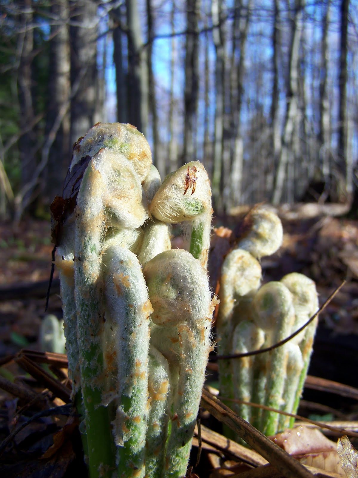
That's right...check out those kick ass ferns!  I probably spent a good 15 minutes photogogging these beauties using the one or two techniques my camera is actually capable of doing.  If I knew I was going to capture them unrolling and springing into fern formation you'd probably be watching a video right now...but I digress.  After documenting the ferns adorable existence...I then found something of equal or greater value as measured on a scale of awesomestness!!!


It's my hand...sweet huh?  Oh yeah, and that thing next to my hand is a bear paw print!  Holy flapjacks Batman!?!  Probably within an hour or so of me being on this trail, a black bear went meandering through and left his paw print in some mud.  I was giddy...like...16 year old prom girl giddy.  Just be glad your reading about it, because if you would have witnessed it, I don't think we'd ever get over the uncomfortable silence. Hahaha.

This was a first for me actually.  I don't think I've ever found evidence of a bear being near me like this before - so of course now I was scouring the woods to see if I could capture a glimpse of this cuddly fuzz ball.  Alas, my lover-bear was no where to be found - but on the bright side he did leave me this:


Classy right?

Sunday, April 24, 2011

My new cache: A fun little update 'cause I'm a dork.

After P-Man and BFG accidentially did one mile of additional "not on the original agenda hiking" in the wrong direction, they were finally able to get themselves turned around and I'm glad to report they found the cache (which what sounds like no additional complications...haha).

For those curious, here is P-Man's log (with pictures) and also ButterflyGuy's!

Congratulations on completing this adventure, even after doing an additional (and unexpected) mile on trails that I know where really wet and muddy!