Sunday, March 27, 2011

PA Weekend with Jeffie – Sunday Edition (Afternoon) – Spawn of Tram Road and Cemetery Hopping

Hopefully this is chronological…as I am prone to fits of forgetfulness.  Hehe. 

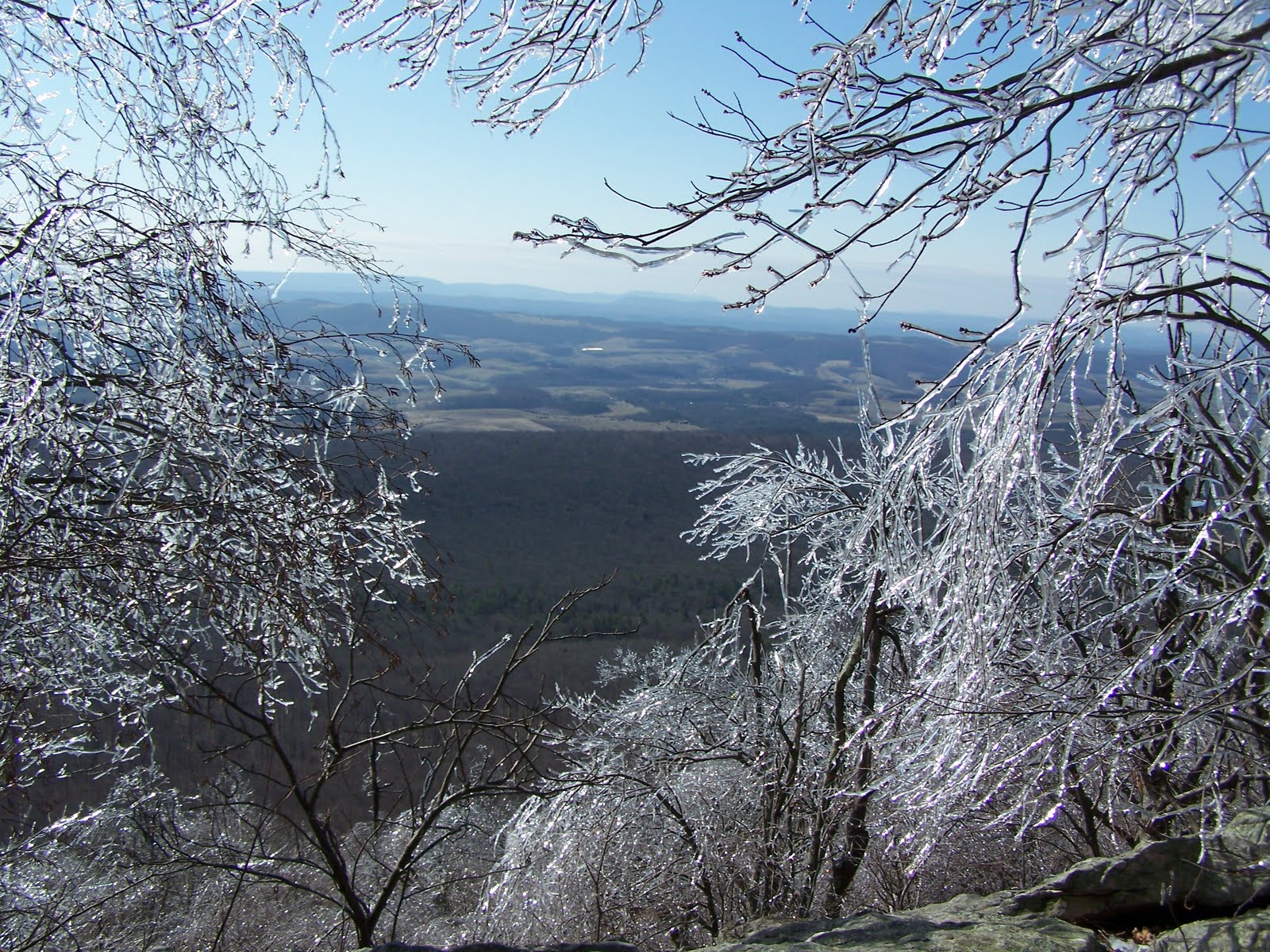
After we were done playing on the Icy Mountain of Doom, Jeff decided he wanted to show me something.  It was a road actually.  Or at least that’s what the Commonwealth of Pennsylvania defines it as.  But before I get into the nitty-gritty – I suppose it’s worth relieving some history.  It very well could be the single most important moment in American history.  You see, during the early 1990’s, Frankfurter Dodge and Maxamillion Plymouth, decided to create a front wheel drive compact car.  They pondered the design for months.  They wanted to build something that would be an affordable grocery getter, provide good fuel economy and have plenty of seating for a small family on the go….oh, and also possess the testicular fortitude of an M1 Abrams Battle Tank.  This insightful vision gave way to the 1995 Dodge Neon.  Not only was the Neon a charming little bug eyed vehicle, it also was the Chuck Norris of the automobile world.  Underneath its hood, was another hood.  That’s how fierce this bitch is.  Anyway, Jeff’s lovely wife Karen owns a brown Neon.  Interestingly enough, apparently only two Brown Neons were ever manufactured (the one Karen owns, and the one the chain-smoking accountant who never says hi or smiles at me when I walk by parks behind my apartment).  

The purpose of this completely factual history lesson?  Back in May 2005, Jeff, Karen and I had just completed a cache called Gum Boot Hill by Salvelinus in Black Moshannon State Park.  After completing the cache, we had the option to continue down Tram Road – to points unknown, OR, to return the 1000 feet from where we came, back to the paved sanctuary of Route 504.  I remember Jeff asking aloud which direction we should go, and I’m pretty sure my response was, let’s have an adventure and keep going (because lazy logic dictates that turning the car around was far too much effort…haha). 

Boy…was that the wrong decision.  The early goings of Tram Road were standard dirt road fare.  A pothole here, some rocks there…nothing the clearance of a normal car couldn’t easily handle.  We started downhill, and that all changed.  Suddenly we were navigating around and over huge boulders protruding from the road – going up and down hills that were designed more for a 4x4 Jeep than a dinky little Neon – and throughout this all, that car took the punishment in almost a masochistic manner.  At one point we passed by a Jeep parked along the side of the road, and the people standing nearby looked at us in horror as this tiny Neon went cruising by.  We bottomed out more times than I could count – and still we kept on going.  After a few miles of rocks crunching into the undercarriage of the car, we FINALLY made it back to a legitimate and passable road.  To this day, we still joke about the Tram Road Incident. 

Well, unbeknown to me, in the last year or two, Jeff and Karen found a road worse that Tram Road…and yes, you guessed it.  The Neon slayed that road too.  So after our run on the ridge, Jeff wanted me to take my Pathfinder down this road so I could fully appreciate the awesomeness of the Neon.  He claimed the road was even worse off than Tram Road.  I had to see it to believe it.  When we first started down the road, I failed to see what the big deal was.  It was just a dirt road.  No biggie right?!?  Hehe…we turned one corner…and suddenly this well-groomed dirt road was replaced with what I can only describe as an extremely rocky creek bed.  I was in awe.  And slightly terrified.  Here I was, in my not-yet-4 month old Pathfinder, and we are driving down the road to hell.  Way to go Jeff!  Anyway, this road was a complete disaster.  Not only were rocks spiking up from the road, but also washouts, gulleys and boulders lining the roadside (in some cases only a foot from the doors).  What the hell Jeff?!?!?

For what seemed like miles, we trudged through this horrific mess.  Even if I wanted to turn around, the road was barely wide enough for my vehicle…so that rendered that escape option virtually useless.  Eventually the road evened out, and we were back on pavement.  You are one lucky turd Jeffery!

Afterwards my heart was thumping pretty good.  That was quite the adventure – and of course immensely stupid.  I was floored that the Neon tackled that.  The fact that I didn’t bottom out surprised me…but the Neon?!?!? 

Eric = mightily impressed

From there we decided to head home and sloth around for a while.  I have to believe Sheetz was involved…because c’mon…why wouldn’t it be?  Haha.  Eventually, with the boy’s weekend quickly coming to a close, we decided to go easy on ourselves and embark on a bunch of park and grabs.  Truth be told, I don’t completely despise park and grabs.  I just don’t always understand people’s motives and or reasoning.  At the end of all things though, quality time with Jeff is still quality time with Jeff…regardless of the location.

If memory services, the majority of the park and grabs we chased after were part of a Rest N’ Peace Series.  The purpose being, to hide caches in cemeteries within Centre County, PA.  Or at least that’s my understanding.  Haha.  Anyway, the Rest N’ Peace caches did take us to some cool out of the way cemeteries (some more “historic” than others).  I don’t entirely agree with placing caches in cemeteries…but then again, I’m not the powers that be so…I’m probably the minority.  I will say that some cemeteries have some great old stones (from the 1800’s) which are always interesting to explore.  Anything newer than that though, seems terribly wrong.  But I’m on my soapbox…so I’ll digress!

Anyway, of all the caches we did, the best one was called Rest N' Peace CC #1 - Benner Cemetery by MattressGnome.  This cemetery is actually located on land just recently purchased by Penn State University from a nearby maximum security prison.  Therefore, up until this purchase, NO ONE was permitted on this land under penalty of arrest.  So after years and years of ambiguity, the public could finally explore this small cemetery.  What blew me away was the make-up of this interment.  It was over a quarter mile hike down an old wooded road to get to the cache.  When you finally exited the woods, the cemetery stood in the middle of a field in the distance like an oasis – surrounded by cedar trees.  I was told once that in many of the older cemeteries, you are likely to see cedar surrounding them.  People believed that the cedar kept any spirits that would be wandering the earth inside the burial grounds.  So when I see cedar, I usually know right away it’s an old spot. 

The cemetery itself was also surrounded by an old stone wall, with a stairway that took you over it and into the grounds themselves.  There we found a dozen or less stones dating back to the early to mid 1800’s.  One of the interred was General Philip Benner – an early local industrialist, and Major General of the Pennsylvania Militia.  Pretty cool stuff!  This was definitely my favorite of the cemetery stops today.

From there we would play for a little longer, before returning to Jeff’s.  I was beat, but at the same time I knew it had been an awesome weekend.  We certainly did about everything you could possibly do this weekend.  From amazing hikes into the woods, to cool caches, to damn puzzles and interesting history lessons…I had a blast.  And if your brain hasn’t turned to mush by reading my incessant ramblings, you can of course can read about all the fun we had on Jeff's blog (while taking note of all the bizarre pictures he was able to capture without my knowledge).

Elijah Chambers - Revolutionary War Veteran. 
One of the cool discoveries during all our cemetery hopping.


PA Weekend with Jeffie – Sunday Edition (Morning Part II) – Ice Ridge

After frolicking in Stone Valley, Jeff decided we would do a few more park-and-grab type caches enroute to our final AM cache find.  Park-and-grabs are exactly like they sound.  A quick cache that typically takes more time to park, exit the vehicle, scratch your bum and grab your GPS than it does to make the find, sign the log and gratuitously scratch yourself some more - all before returning back to your vehicle.

I won’t go into the thrilling park-and-grabs we violated on our return trip from Stone Valley.  Partly because I didn’t log them (and therefore don’t remember what happened)…but mostly because I’m lazy, and you can only riff about the sweet majestic texture of a guardrail for so long before you choke on your own vomit and die.  I’m being dramatic.  Okay, no I’m not. 

Anyway, our return trip took us along Route 26 and to the top of a massive mountain ridge just above the town of Pine Grove Mills, PA.  This ridge contained several exceptional caches, including David's Vista by Diggles and Liggles (adopted by IV Warrior) and Cajeput by Jut, Mari and Beth.  Two old school caches I found in 2005 when I was as green as Pennsylvania is hilly.  They both stand as some of my all-time favorite cache finds.  We crested the hill, and about halfway down towards Pine Grove Mills, we took a left on Kepler Road – a dirt road that took us along an exceptionally scenic drive below the ridge.  Eventually the road turned into Pennsylvania Furnace Road, and made a crazy hairpin turn up to the top of the ridge.  There we parked – where I realized we’d once again be hiking the Mid State Trail.  I know I’ve beaten a dead horse into a fine sand-like powder over this, but I can’t help it.  I love this stinkin’ trail.  Its awesomeness borderlines on the unfathomably insane. 

Our plan was to hike a quarter mile along the ridge in search of a cache called Old Fire Tower by Biker1959.  Upon exiting the vehicle, we realized that the entire forest was coated in a thick layer of ice.  It was stunning.  Turns out, it was also extremely hazardous.  Haha.  With the sun gleaming off the frozen bows, it was just warm enough to occasionally cause shards of death to hail from the sky at our precious little melons.  Hmm…this was an unforeseen danger!
See - - ice!

Vista from 15 feet from the cache site...amazing.
We hiked in, enjoying the views from our frosty little hill.  When we arrived at the cache site, we noticed the old cement foundations from the fire tower.  In its glory, the overlook of the now deconstructed fire tower must have been one hell of a view.  As it was, we could look out from the ridge and see for miles.  It was superb – and to have all of this framed by the ice covered trees…made it even more sensational. 

For a little bit we poked around for the cache, mostly distracted by scenery…but eventually we laid eyes on it, and as Jeff signed us in, I scampered about the rocks on the hillside finding good vantage points to take more pictures.  Jeff rehid the cache, and we convened back at the top of the ridge along the MST to take a celebratory picture, commemorating our ‘guy love.’  From there, we returned to the truck, and headed back down off our mountain for some crazy afternoon adventures.
It's guyyyy looooveee!!!

PA Weekend with Jeffie - Sunday Edition (Morning Part I) - Stone Valley n' Duct Tape

With a lot of hiking crammed into Saturday, Jeff and I were a little tired.  That doesn't mean we weren't up for more wilderness adventures...we just needed to pace ourselves a little.  Getting old is a bitch FYI.  Haha.  Yesterday we had found The Enchanted Forest, which had spent just over a year hanging out in the woods all alone without anyone to come and find it.  In the geo-community that's called a "lonesome" cache - which can be a shame, especially if it's a good cache.  Well, there just so happened to be another lonesome cache in CPA that had caught our eye - and that was Duct Tape by the REST Seekers.  This particular cache had not been found since September of 2009! 

*Insert shocked face here*

Part of what might have been causing this cache's bitter loneliness, was the fact that it's a puzzle cache.  So basically you had to solve a puzzle in order to figure out what the coordinates were.  As fate would have it, Jeff and I are apparently awful at puzzles.  Put us together and our best efforts to crack the simplest of code could be described as abysmal, horrid, and outrageously putrid.  Yeah...we suck that hard.

For the better part of the weekend we had stared at this cache trying to figure out what the puzzle was, and how we could solve it.  We eventually took pity on ourselves, and reached out to another cacher for a hint.  The hint only made things worse...so we asked for another.  That didn't help either.  At some point we were ready to plead for an 8 x 10 glossy of the coordinates to save the continued suffering of innocent grey matter.

It was Jeff who finally cracked the code.  Under normal circumstances, I'm pretty sure a distracted 10-year old probably could have figured it out, but for whatever reason we just didn't see it.  Regardless...the cache coordinates were in our hands and we were off into the morning sun to be the first finders on this cache in 1.5 years!!!  Yessssssssssssssssssssssssssssssss.

Jeff shows off the antique logbook - first finders
in 1.5 years.  Let the geeking-out begin!

The cache was hidden in Stone Valley Recreational Area.  This 700 acre chunk of change is owned and operated by Penn State University which pretty much owns everything in Central PA.  I was going to make a joke about them owning more land than Robert Redford, but I can't find a good link to further my point...so I'm scrapping the joke.  Moving on...!

We headed to the coordinates, and there we found a container with another set of coordinates that took us deep into the woods.  As we are all aware, this is the kind of caching I love the most.  I don't remember how long a hike it was (maybe less than a half-mile), but the scenery was really pretty.  There was plenty of hemlock and hardwoods to keep us company - and after covering the distance - we arrived at the cache location.  After doing a few somersaults to accommodate Jeff's possessed GPS, we found the cache!  The ancient prophesies proved true, because we were indeed the first visitors since 2009.  That's a really cool feeling.

For a little bit we pawed through the goodies, and eventually we packed up everything and made sure we rehid the cache good because who knows when it will see any love again.  All in all we were pleased with ourselves - two caches in two days that had not been logged as found in over a year. 

From there, Jeff wanted to continue on down the trail, and make the loop back to where we entered the woods.  So we did.  Apparently, I had hiked here before and didn't realize it.  Haha.  It was nice getting back here though - as Stone Valley is extremely scenic (just like most everything in PA I guess...haha).

Jeff shaking his bum along the loop in Stone Valley.
This was a great way to start our morning...but it was only the start.  There was much more adventurin' still yet to accomplish!

Saturday, March 26, 2011

PA Weekend with Jeffie - Saturday Edition (Evening) - State Gamelands!

I'm probably going to butcher this...and at some point in 2037 when Jeff remembers I actually blog, I have no doubt he'll correct any errant fabrications...but Pennsylvania is much different than New York in how they manage their parks, forests and other public lands.  In New York, we have town parks - which are governed by the particular township that they reside in.  In New York we also have County Lands, as well as State Forests and State Parks.  In the great all knowing Commonwealth of Pennsylvania, the Department of Conservation and Natural Resources manages just about EVERYTHING.  So basically if you want to place a cache in a little town park down the road, the DCNR has to approve it.  It's certainly a lot more bureaucracy - but for how much work the DCNR does in making PA parks awesome, I can't blame them. 

Now...the caveat to this pointless boring drivel: there exists something in PA called State Game Lands (SGLs) that somehow circumvent DCNR oversight when it comes to placing caches.  I don't now how that works, and frankly, my head hurts so bad from trying to make sense of what I've already written, that I'm just going to accept it and move on with this damn blog.

Alright..................I lied................I looked it up.  It seems the SGLs are managed by the Pennsylvania Game Commission.  They must be a separate function aside from the DCNR. 

You're probably wondering where I'm going with this huh?  Well at first I was going to try and distinguish the difference between SGL's and the rest of the world...but then curiosity got the best of me...and as a result you all had to suffer.  I'm sorry.  The true purpose in all this is to explain that the rest of our caching adventures for today would all occur on SGL's - which are usually numbered (SGL #1, SGL #2, etc.)  But for the life of me, I'm not even going to try and wrap my noodle around that...

Anyway - after a long morning/afternoon of spelunking, rock climbing, hiking, drooling, and standing amidst the natural beauty of CPA trying to keep our heads from exploding from sheer enjoyment - we returned home to eat and sloth away the rest of the afternoon watching day old college playoff hockey (or whatever other random things were on cable TV).  Eventually we caught our twelfth or so wind, and decided to hit up a few more caches later in the evening.  So Jeff started scouring the internet, and in short order he had picked two caches for us to check out.  They were:
For acting like a sweet innocent cherub, Jeff is kind of a sneaky bastard.  Which is why I love him, but still...you have keep an eye on him.  I say this because the first cache was a multi, which required us to find several stages before finding the final.  The final was a film canister, which is classified in geocache speak as a micro.  Eric doesn't usually like micros as he likes find nice big ammo boxes in the woods.  Ideally, I like anything that shows me something sweet...but the larger caches always make me happy.  I'm a nerd...who rambles...a lot.

Anyway, Scotia Mines was actually a really awesome area.  It was pretty removed, with well defined trails, little bridges and some beautiful open woods scenery.  Added to this, was the fact that there were still remnants of the old mining operation that existed here from the late 1800/early 1900's.  If you want to geek out further (because we all know I just did...), check out the history I found bitches or hereeeeeeeee!!!  The highlight (unexpectedly of course), was when we were on our way back from finding the cache and came across an overlook of a pond that I imagine was at one time a mined out crater that had since filled with water. 

Strewn about EVERYWHERE was a myriad of spent ammunition...deer slugs...pistol and rifle cartridges...anything you could imagine.  Clearly the visitors to this spot are living the gun toting hillbilly stereotype.  Hahahaha.

Our next stop was the Yellow Cache - yet another hide on SGLs.  This dandy was a sub-half mile hike leading to my beloved ammo box hide.  Not too much crazy happened on this particular hike, but I do remember enjoying my time chatting with Jeff.  I love that kid so much.  (I know, a sappy geek...I'm hopeless).  This would be our final hurrah for this super busy fun-filled Saturday of caching.  We had seen and done so much...it was awesome. 

Don't worry though faithful readers - Sunday is chalked full of more stupendous adventures starring everyone's favorite (and exceptionally studly) heroes!

PA Weekend with Jeffie - Saturday Edition (Afternoon) - The Enchanted Forest!

After the fun and frolick(ish) at the Tunnel with the Funnel - Jeff, Galen and I headed out to tackle the main objective of our venture into the PA today.  The golden apple of our lusty eye was The Enchanted Forest by RGBisme and Salvelinus.  Something I should probably note before I get too far...is that I get pretty hyped up to do a Salvelinus cache.  One of my all time favorites is a cache he placed called Serenity which involves a four mile-or-so hike through beautiful open woods, the entire time following a babbling brook with moss, rhododendron, and all the wonderful goodness that you could ever possibly ask for in a outdoor hike.  Since finding Serenity back in 2007, I always eagerly look forward to tackling more Sal caches.  Sadly I don't get to do nearly enough of them (which goes for many superb caches in Central PA...but still!) 

Anyway, this cache was our goal for today for a couple reasons.  It comes highly recommended by many CPA cachers, it's a few mile roundtrip hike, and it's been just over a year since it's been paid a visit (and logged) online.  That seemed like a horrible shame, so Jeff and I eagerly looked forward to trying this.  The first part of the hike was along Stillhouse Hollow Road - an old dirt road, that would have been easily passable for higher clearance vehicles.  Since we had the Mighty Dodge Neon though, we decided it would be best to walk the mile or so to the trailhead. 

Now I won't go into great detail, since that is a blog and change all unto itself, but the Dodge Neon is probably one of the best all terrain vehicles ever designed to not be an all terrain vehicle.  I know this because I witnessed it first hand sometime in May 2005 after doing (ironically enough) another Salvelinus cache called Gum Boot Hill.  But I won't bore you with the immense awesomeness of that adventure seeing as we're already a couple paragraphs into THIS awesome one. 

I love happy little creeks!
Anyway, the walk along Stillhouse Hollow was extremely scenic.  To our left was another wonderfully babble-filled creek - and to our right - low hanging hemlocks glowing in the afternoon sun.  It was a wonderful way to start our journey!

The hike in was phenomenal (and as we later learn, all down hill...haha).  After a mile or so, the road became more a path, and soon we arrived at the juncture with my new favorite trail - the Mid State Trail.  We spent a few minutes enjoying the sun, the creek and the fact that Galen misplaced his frisbee.  Eventually we set off down the MST - and we weren't disappointed!  Just like I had hoped, we spent the majority of the hike along the banks of the creek with the towering hardwoods over our head, the evergreens brushing our cheeks and the rhododendron covering the sides of the trail.  It is far too beautiful to ever try and put into words - and the only way to really know what it's like is to experience it.  So should you ever get the chance, don't ever pass it up! 

After a short distance we came to the first of two very unique bridges we would run into while on the trail.  I can't recall I've ever seen bridges like this - so I had to take a few pictures just so I could share with the masses...and maybe if someone reads this (IF anyone ever reads this...haha...they can let me know where they may have found something similar).  Here's a snap shot of the now infamous two lane - one rail hiking bridge!   

Wicked neat right kids!?!
The cache was probably a little over a half-mile from our jump on to the MST, but I'm pretty sure it could have been 10 miles and we would have hiked every last foot with ridiculous grins on our face.  Well, for the most part.  For a few moments we thought we had lost Galen (shhhh...don't tell Karen), but like the mildy responsible babysitters that we are, we finally found him and tied him up with a demeaning puppy leash.  Haha.  Soon we arrived at the cache coordinates - and from there the search began!  My initial reaction was that since this cache had not been reported as found in over a year - our work might be cut out for us.  Thankfully Jeff was able to get cell reception deep in these woods - and learned from a previous log that the coordinates were a little off - but that a previous finder had given a decent heading as to where to look.  The directions were perfect, and we quickly saw a likely spot - and then - SUCCESS!  We were really stoked to find such a lonely cache!  We cracked it open to check out the letterbox stamp inside.  Hmm...I probably should explain that huh?

Let's define a couple things first.  Geocaching is an activity where you use a GPS to follow coordinates to a specific location, and find a container hidden by someone.  This game is based on a premise that's been around since the mid-1800's called Letterboxing.  While Geocaching relies on technology - letterboxing relies on perception.  Basically to find a letterbox, you would follow clues in order to find the "treasure."  The additional difference with letterboxes is, that when you find one, people usually leave a stamp inside that you can ink and stamp into your own book (should you choose to have one).  It's pretty neat, as some people are extremely creative and artistic. 

This stamp is extremely awesome...
and not just 'cause there's a unicorn on it.  Haha!

The Enchanted Forest is considered a letterbox hybrid - which is just a fancy term for a letterbox you find with a GPS instead of clues.  So within the geocache, was an amazing stamp that was carved by RGBisme Posse (who are pretty renowned in CPA for thier exceptional boxing stamps). 

For some reason I left my stamp at home...because I'm dumb...but regardless, I was able to take a myriad of pictures of this one.  I've tried to make a few stamps before, and it really is a challenge to carve one in as much detail as this and have it come out this good looking.  So needless to say, I was truly impressed. 

For a while we enjoyed our find, the splendiferous of this stamp and the general feeling you get when everything falls into place.  We were really happy, so of course we had to take some celebratory pictures with "the boys."  It was great, and I was so happy I could share this with Jeff.  How could this weekend get any better? 

I guess you'll just have to read on to find out.  Haha.


PA Weekend with Jeffie - Saturday Edition (Morning) - Funnel at the Tunnel!

Our first stop of the day was Tunnel Funnel by HolyCowboys. One of the benefits of Pennsylvania’s extremely hilly terrain, is that during the rail-road era, many tunnels were bored through the mountainsides. As the age of railroads began to die off, many of these tunnels were left abandoned and in disrepair. The State of Pennsylvania does a phenomenal job in highlighting natural and “unnatural” areas - so as they developed trail systems, they had the foresight to highlight these tunnels for people to visit and explore. Go PA, Go PA!

Anyway, this was our first stop on the day. It was actually supposed to be our second, but Jeff accidentally took us down the wrong dirt road, which in turn landed us on the wrong side of a ridge. Which for those familiar with PA, know that going in a north-south direction is not easy. To go 3 miles north, you might have to do about 15 miles of driving because the roads usually go around the mountains - not through them! Since Tunnel Funnel was on our agenda anyway, we knew there was no harm in making it our first play-date of the day.

After tripping the dirtroads fantastic, Jeff, Galen (token dog) and I arrived at the parking coordinates in Poe Paddy State Park and the majestic Bald Eagle State Forest. We headed out on our short quarter-mile hike along the Mid State Trail.  I'm pretty sure I'll mention this at least a few more times in the next few blogs...but the Mid State Trail is EPIC.  Clocking in at a grand 320+ miles, and slicing the state in two from north to south...it provided me with one unbelievable experience after another.  So if you ever get the chance, make sweet hiking love to this trail.  You'll adore every step!  Anyway, while the hike was indeed a short one, there were plenty of sights!

The view crossing the bridge over Penns Creek!
Probably one of my favorite hiking experiences, is when I get to hike through open woods along a creek. Add the hills and beautiful landscape behind it all into the mix, and you have yourself an exceptionally scenic spot. I love it.

We crossed over Penns Creek, and no sooner did we finish crossing the bridge - there stood the tunnel in all it's glory!

I was pretty dang impressed, because the tunnel was rather hidden by the low hanging vegetation - but as I approached I had to stop about a hundred times to snap pictures. I felt bad for Jeff, as he probably had to mind all the drool I was leaving in my wake. Haha.

The name of this cache wasn't immediately obvious to me as I didn't quite understand what the heck a funnel would be doing in a tunnel. Eventually it dawned on me (it took probably longer than I’m willing to admit…haha).

At the exit of the tunnel, the State had reinforced it with a smaller tunnel taking you the last 100 feet or so before you made it all the way through. It wasn’t very large either as for the last 30 feet or so I had to duck a little just so I wouldn’t smack my head. Ahhh, the luxuries of being freakishly tall.

Jeff and the entrace to the Tunnel of Funnel.
Once on the other side of the tunnel we entered into a beautiful scene, with Penns Creek in the background and a hillside full of….rocks?!? Yes folks…a hillside full of rocks. It’s pretty standard fare in PA, but it makes finding caches a whole hell of a lot more complicated. Imagine if you will, trying to find a needle in a haystack, but potentially hiding under each and every reed of hay was a poisonous rattlesnake. Sounds like fun right? Luckily for us, it couldn’t have been much more than 40 degrees this sunny morning, so the danger of us actually running into one of those beasties was at a minimum…thankfully! Unfortunately, the rocks would do us in because after a little searching, we came up empty.

I will say we made a valiant effort, but seeing as we were the first reported seekers following a long winter, the cache could be super duper buried. We were a little discouraged, but it was quick to dissipate once we refamiliarized ourselves with the stupendous scenery we were basking in.

The other side of the tunnel!
For being such a short hike in, spending an hour or so climbing all over unstable boulders sure can wear a dude out. Every once in a while I’d prop myself up on a rock and enjoy the sound of Penns Creek gurgling at the bottom of the hill and the sounds you can only get from being in a removed spot out in nature. From time to time I’d also have to figure out where Galen went to! He was a pretty good boy, as he found a great deal of entertainment in running around with his Frisbee. My ultimate complaint is that Jeff has done a piss-poor job in training Galen to find caches. This would have made our job much easier!

 Eventually we had enough of searching and decided to pack it up and slowly make our way back to the car. Of course this meant playing in the tunnel again!

Squeeeeeeeeeeeeeel! Deep down I’m a nerdy little girl at heart. Hehehe. With our gear all bundled up, we hit the trail and again I was able to enjoy the peace and quiet of my beloved tunnel on our way back to the car and many more PA adventures!

Silly Szuchie Trivia: according to the Mid State Trail Association of Pennsylvania, this is the only tunnel on the MST.
Mid State Trail!

Friday, March 25, 2011

PA Weekend with Jeffie - Friday Edition - I ~HEART~ Sheetz and Friday Night Hikes.

As I was trying to think about how to start this blog, all I had running through my head was that memorable scene from The Wedding Singer where Jon Lovitz is crooning this tune.  There’s relevancy there I swear, but it’s so ambiguous and skewed I don’t think I could explain it if I tried.  Haha.

For a few weeks now, Jeff and I have planned a boys’ weekend.  Truthfully, I can’t tell you the last time we’ve had a boy’s weekend as it seems like it’s been forever and ever.  When the opportunity arose, I had to make the absolute most out of it.  The boys’ weekend was to span a little over two days – starting upon my arrival into State College Friday night. 

So we’ll start with the drive down and my love affair with Sheetz.  Haha.

I wasn’t smart enough to ask to leave work early, so that meant I’d be leaving around 5:30ish – with an estimated time of arrival at Jeff’s front door around 9pm.  Now that I think of it, it probably would be a little after that, as there was a stop in Ridgeway that I’d have to make - and believe me - I’d have to make it!  For those who don’t know, I have an unnatural adoration with Sheetz.  Usually when I tell people this, the first question is: “What the hell is a Sheetz?!? 

Sheetz is like a bastion of convenience, littered about portions of northern and central Pennsylvania.  It’s as though this company has found a way to capture magnificence, cut it up, and sell it in bite-sized portions for my euphoric consumption.  Alright, so maybe that’s a little much…but let me tell you, this place is pretty freakin’ sweet.  They make all food to order, and if you like playing with touch screens as much as I do when ordering a bevy of tasty treats, it’s not just ordering a meal.  It’s one-step away from a video game. 

I digress. 

In Ridgeway, besides some historic stuff and a bizarre plethora of runaway truck ramps, there’s a Sheetz convenience store.  A one stop shop for gas, shmagels, shmiscuits, shmuffins and any other foodstuffs you can add a “sh” prefix to.  You’d think after several years of frequenting this establishment, the novelty would have worn off - - sadly - - it has not.  Ridgeway Sheetz is the first Sheetz I pass on my way to Jeff’s.  Hence, it is a required stop on my way south for gas, food, drinks and the general delight I absorb from its Sheetzy ambiance.

When I got to Sheetz, I realized I wasn’t very hungry.  I had to get gas anyway, and decided that I couldn’t not get something - so I ended up nabbing something easy, yet delicious.  A small cup of Sheetz fries and a diet cherry Pepsi.  A dinner of champions indeed.  With the obligatory Sheetz stop behind me, I made the rest of the journey to State College without anything blog-worthy to report.

I wandered in Jeff’s front door to find him playing Rock Band.  We performed the ceremonious “Guy Hug” ritual, and then started talking about our weekend adventure.  At some point we realized that Jeff was sitting on a zero day, and since I had spent the last four hours driving around, I was a little antsy in my pantsy and wanted to stretch my legs.  Even though it was the 9pm hour, we decided to check out a few local caches that Jeff had yet to find.  I think the reason this was such an agreeable idea, was that it was a beautiful night out.  The sky was partially overcast and there was a chill in the air – but for me it was perfect weather for a nice hike.  Jeff decided on the following two caches:
You’ve Got Mail was located near the confluence of a bike path and rails to trails – just a short jaunt from where we parked.  One of the things I learned very early on when I started caching with Jeff, is that he’s not one to take the road more traveled.  In fact, he prefers to mow his own path - throwing practicality and sensibility to the wind.  For the spectator, this would be a very entertaining thing to behold.  However, for those of us that follow him, it’s equitable to wading across the brink of Niagara Falls to get to the other side – while everyone else uses the footbridge.

Such was the case with You’ve Got Mail.  Flashlights in hand, we approached our zero.  There we found a massive dirt mountain standing between the top and us, where presumably the cache was hidden.  Once Jeff’s nose is in the GPS, not much will stop him – so scaling the dirty muddy hill we went.  Summiting Mount Mud, we learned that if we had just parked behind a nearby hotel, the walk would have been short, flat and much less dirty.  Oh Jeff…..

Anyway, we made our way to the end of the mountain and there we found a mailbox – inside of which was the cache.  This is something I’ve seen done before, but I think it’s a cute idea so – it makes me smile.  We signed in, and back down the dang hill we went!

Our second and final stop for the night would be Cross-Eyed Cache.  This cache was hidden down the rails the trails we had passed on the way in to climb Everest.  I don’t remember exactly – but I believe the cache was a mile hike one way.  The roundtrip hike for this cache would become one of my favorite highlights from our weekend.  There was just enough light in the night so we could keep track of the trail – so to conserve batteries we turned off the flashlights.  We spent every step of the two-mile roundtrip chatting about life, caching and all the little stuff you need to catch up with when you spend quality bonding time with your best friend.  It was great, and honestly, I probably would have kept walking just because. 

Eventually we arrived at the cache sight, and Jeff immediately found the cache.  We did our administrative duties, and headed on back down the trail.  I had a great time making this hike, and when we finally did return to the truck, I was extremely pleased.  I couldn’t think of any better way to kick off this weekend than the adventure we had just completed!

Prologue: A Weekend In The Wilds

This evening I will be moseying down south to visit the epic metropolis of State College, Pennsylvania to visit with my BFF4E, Jeff.  There will be a bunch of hiking to be had, and plenty of good times to boot.  Heck, maybe if the winds of fate blow us in the right direction, we might even spend some quality time bogging down Tram Road.  I'm really looking forward to this weekend - as it's just us guys!  Yay for the PA wilderness and time with Jeffie!!!

Thursday, March 24, 2011

My first bloggable Letchworth hike!

My adventures on Sunday 3/20/2011:  You just plum could not find a better day to be outside hiking then this day. The temperature planned on hovering in the mid to upper 40’s, the sun was out all beautiful and bright, and the snow was nearly impossible to find anywhere along the Finger Lakes Trail in Letchworth State Park.

The day before I had headed to Leicester to play along the Greenway Trail. To get there, I took the round-about route down through Portageville, hugging the east side of the park as I made my way north. The purpose of this was to do a little reconnaissance and ascertain how much snow might be tucked away in these woods. As I drove, I didn’t see hardly any snow – and with that – the deciding factor was set in place – Sunday would be a hiking day in Letchworth along the Finger Lakes Trail.

This might be a little biased… and since it’s my blog you’re bound to run in to a little of that… but I think Letchworth State Park is one of the jewels of the New York State Park system. Almost every NYS Park I’ve visited is awesome for a variety of reasons – but Letchworth is something otherworldly. It’s called the “Grand Canyon of the East,” as the Genesee River has created a 17-mile long gorge with multiple waterfalls and in some places cliffs that are 600 feet high. Every spot in the park will leave you drooling in awe – it’s that awesome. Besides all that jazz, the Finger Lakes Trail (FLT) also runs along the east side of the Park. It clocks in at about 24 miles of deep woods hiking goodness. The thing I should also mention is that the east side of the park is the “wild side.” It’s not very developed; there aren’t many roads or man-mad facilities to be found. The west side is the touristy side, and the east…that’s more for the hikers baby!

Anyway, the plan today was to spend a few hours hiking the FLT to go to a spot I had never been before. On Letchworth maps, it is only classified as a blue side trail off the FLT. However, the folks from the Finger Lakes Trail Conference call this dandy spot Owl Forks Ravine. It’s a bizarre physical feature when you look at it with topography maps. Here you’ll find a thin ridge that runs parallel with the Genesee River –with a ravine running along the other side eventually cutting a fine point at the end of the ridge where it dumps into the River. Bizarre stuff – and I was curious to see it for myself. What furthered my interest was that the shortest route to and from this ridge involved a six-mile roundtrip hike. So if you’re keeping tabs: this spot was awesome, unique and removed. If that isn’t destination worthy right there, I don’t know what is!

The thought of doing a hike in the 5 to 6 mile range was a little daunting. It’s been a long winter and I’m not exactly in prime hiking shape. I figured this would be a good chance to see what I was capable of doing. The experiment began a little after 9am as I started down the Sycamore Hiking Trail – an access to the FLT that runs perpendicular through it and meanders down into the gorge where you’ll find a massive Sycamore that’s a few hundred years old (and I believe is one of the larger Sycamores in NYS). It’s a super awesome tree, and anyone lucky enough to have the chance to make the trip should before it’s gone. Word on the street is that the river is undermining it…so it’s only a matter of time...

Anyhoo – the grand total hiking distance from my truck to where the Sycamore Trail met the FLT was just over a third of a mile. I’m a 20th of the way done with my journey! I love measuring hikes in fractions and percentages. It gives me a sense of accomplishment (and towards the end of longer hikes a bit of light at the end of the tunnel…haha). Here’s a picture of what miniscule progress looks like:

 
I threw on my pack, marked this particular intersection in the GPS, adjusted my stylish circa-2001 visor and took the first step along the FLT. It was a big step, seeing as I hadn’t done much of what I consider long distance hiking since…well since I couldn’t remember. The early going was good, and then I hit my first hill.
If you look at the trail maps for the FLT, you’ll notice some sections of the trail (like the one I was on) are very curvy and bumpy. Sort of like a sound wave – with noticeable peaks and valleys. This is due to the fact that there is a myriad of tributaries cutting through the trail as they head downhill towards the Genesee River. Usually as your going to the brink of a curve you’re going to be crossing one of these tributaries - and as such it’s an uphill jaunt to get to the creek crossing. The first one was mild (they usually are), but it was still enough to get me huffing and puffing and wondering if I was making the right decision. I questioned my bodies ability to cart my large frame such distances, but I figured I’d go as far as I could go - damn the consequences.

The first ravine was behind me, and from there it was downhill. It was then that I was really happy about my decision to hike today. Then I started to think about the cache I wanted to place here so I could share this tract of land with fellow geocachers. Then I started to think about what I wanted the cache to be called, and finally, who I should dedicate it to. I thought about my Dad. I thought about Chicky. I thought about Cayuga. I even thought about the Green Tortuga and Sam Gardner. It was my Dad though, that I thought about the most. I miss him a lot, and I hoped he was watching me. It’s been hard…the last two years. I think he would have been glad to know I was hiking, smiling and enjoying myself…it seems like it’s been years since I could say that and really be confident about it. That’s all I’ll say about that...for now.

I was happy - and the farther I went, and the more ground I covered - the happier I became. I started seeing so many beautiful sights…things I hadn’t seen in years. It was a special day to be on the FLT. It was a good day to be me.


After nearly three miles, I arrived at the side trail to Owl Forks Ravine. I was a little surprised to feel this good. But in my head I realized that I hadn’t even crossed the halfway point of my journey - so I wasn’t about to bust out the “bubbly” just yet. The Finger Lakes Trail is blazed in yellow, while the side trails are blazed in blue. So up hill along the blazed blue trail I went! At the time I wasn’t really sure how long this trail would be before it dead-ends - but all told it would turn out to be about a .40 mile walk. This spot was even more impressive then I could have imagined. I found myself hiking a pseudo-knife ridge all the way to the point - where I discovered breathtaking sights!


I just couldn’t get enough of my discovery - and while I knew others had been there before me - I fancied myself a true explorer. Blazing a trail to places never before visited…by me at least. ;-) This was the payoff for my now 3-plus mile hike…and after snapping a bunch of pictures, I just sat there, propped up against a hemlock tree. This is what it was all about…


In total I probably spent a good hour there before I packed up and started the long hike back. And it was long…but I managed. I made a few more stops to rest and hydrate then I did when I hiked in. My pace was noticeably slower and the hills didn’t come as easy either…but I kept a decent gait and after 4.5 hours and 6 miles of hiking I finally arrived back at my truck. I was exhausted, but I felt an inexpressible sense of accomplishment. I’m already looking forward to getting back here - and am even more excited to hopefully lay out a cache to share these exceptional sights with my friends.

Wednesday, March 23, 2011

In-Blog Product Placement: Genesee Valley Greenway Trail

Wow, I’m really behind on blogging…thankfully as I write this, there’s 6 or so inches of heavy foul looking snow laying on top of the world outside so…  I suppose what I’m saying is: I’m not in jeopardy of getting any farther behind in blogging.  Haha.
 
Last Saturday (3/19/2011) I had a zero day.  With weekend zeros, I usually like to expand my caching radius and head to places a little farther out.  That way I’m not picking off the low hanging fruit that come in handy when I need to eradicate a mid-week zero close to home.  With this disturbingly logical and well thought out strategy in mind, I decided to head towards Leicester to play along the Genesee Valley Greenway Trail.  The Greenway (hereafter referred to in a leisurely inconsistent way as the “GW”) is a nearly 90 mile hiking trail that starts in Rochester, New York and runs in a southwest direction ending up somewhere around Hinsdale, New York.  It’s about as level a walk as you’ll find seeing as it was built on a rails-to-trails.  The rail that the trail was built on, was itself built on segments of the Genesee Valley Canal.   The Canal, in turn, was built upon portions of a trail established and utilized by the Native Americans.  Ain’t it funny how things like that come full circle?  For more fun info check out the Friends of the Genesee Valley Greenway.
 
Anyway, the trail itself is nice – and while some spots can be a little boring – other sections are tremendously scenic and secluded.  In some sections, you’ll discover kiosks that explain the history of the area, and in Oakland, NY there are segments of the old canal system that you can view and check out.  History abounds on this trail – and as such – my ultimate plan was to enjoy a few miles hiking along it.
 
There were three caches on my itinerary today.  They were: 
All of them were nicely done – inevitably ending with ammocan hides along the trail.  The one thing you will find in ample supply along the GW is poison ivy.  That stuff is everywhere, and in some sections you’d be hard-pressed to find a tree without a vine or two running up it.  Yuck – you can keep that junk Mother Nature – I loathe it!  Although a couple years ago I became pretty good at identifying what it looked like (after spending 25-plus years of playing in it and suffering the merciless consequences).  So now I keep a close eye out – especially when I’m playing on trails where I know the rubbish is everywhere!
 
After I was done finding my caches, laying waste to another zero day and returning safe and sound to my vehicle, I decided to visit some geo-friends of mine.  The first stop was Brogan’s in fun-filled Warsaw, New York.  Brogan is a character...and by mentioning him, it makes me wonder if I should do a run-down of my geo-friends…hmmm…  Anyways, after spending time at the Brogan Ranch, I headed to Castile to visit Paleoman.  He was out in the man-cave smashing rocks.  He’s a flintknapper.  He's a geocacher.  He's a cavemen.  Clearly there’s a lot to say about P-Man…so I’ll hold of on that for another day.
 
All in all, this was a phenomenal day!  And of course, pictures...


Who doesn't love a theme cache with a funkily camo'ed ammocan?  Haha.

The GW = Hecka Flat

Look Maw!  Varmints!

Now…onto my Great Big Sunday adventure…

Friday, March 18, 2011

A slight tingle of anticipation...

Alright, so tomorrow I'm heading out to fulfill a zero day.  Normal stuff right?  Mostly.  But this particular zero-day hike is centered around the town of Leicester (pronounced Lester...which I don't get...)  This spot was picked strategically because it's on the way to Letchworth State Park (in a round about kinda way).  My intention in doing this, is to inspect how much snow remains in them-thar woods.  The plan is simple...should the snow be minimal to non-existent on the east side of LSP - a Sunday trip might be in order to start work on a geocache that after three years I feel inspired enough to start working on. 

I really want to make this cache happen...because I think if I do it the way I want, it will end up being a 6-plus miler.  Not only will this be a hearty hike, it will be through some beautiful woods that I love.  While I'm not sure I'm in hiking shape to do all the 6 miles just yet...I want to start wandering around to see what I can see. 

So THIS GUY is pretty excited at the moment.  Updates on my discovery tomorrow!

Wednesday, March 16, 2011

Turd-whisperer

So yesterday was yet another zero day - so I was out the door to do some mid-week caching.  I sort of like caching in the middle of the week because it breaks up the monotony of coming home and staring at my walls. Note that my walls are not very entertaining, so the preceding sentence is a bad thing.  The destination today was a cache which I'm assuming is in Hermitage.  The cache was called A Micro In The Woods by Snowman257.  Contrary to its name, the hide was listed as being regular-sized.  So clearly there was some mystique surrounding this cache which caused me to guess many things (all of which were way off...haha...but more on that in a second).  The layout of my journey would be to cut through a hundred-feet or so of field and enjoy a nice tenth of a mile walk into the woods to find my prize.

Well...I arrived at the parking, jumped out of the truck, got into my jacket and mud-boots, grabbed my GPS when all of a sudden something struck me...why does it smell like shit out here??!?!?  Yes folks, just that day they spread liquid fertilizer EVERYWHERE.  It was unbelievable timing...and so there I stood pacing the shoulder of the road trying to decide whether the 100-foot walk through a shit covered field was worth it.  Of course it was, because turning back didn't seem as hilarious as wading through a foul smelling mess.  :-)  So I made it into the woods, Turdy Mc-Turds caked to my boots and in short order I arrive at the cache.  Everything I imagined a cache called "A Micro In The Woods" being was so completely off...  Check this out!


Yes folks...hanging 20-some feet in the air was a microwave IN THE WOODS.  Un-freaking-believable.  I couldn't help but laugh my ass off.  I have to admit, I really do like Snowman's style.  So after opening the cache and checking out the contents I made a HORRIBLE discovery.

There...

Was...

No...

Pen.

You want to know panic...watch a guy who slogged through 30-plus yards of liquid turd suddenly realize that the only way he can sign in is if he goes through that slop three more times.  Being the ethically confounded dweeb that I am, couldn't possibly claim a find on something were I didn't properly get my name into the logbook.  So I had to improvise:


 You might be asking yourselves...

"Self, did Szuchie use the toxic feces on his now stanky boots to doodle his name into that log book???"

One might never know!  Haha.  In the end I just posted a note on the cache page because I really prefer to log in properly.  So I guess I'll be going back bitches!  Check out the full cache log if you're really interested.

From there I still had the wicked conundrum of filling my zero day.  Thankfully on my way home there was another Snowman257 cache called Richard Romesser Memorial Veterans Park Cache.  This was a really exceptional 5 part multicache that offered nearly a mile hike in total.  Each leg was different, creative and unique and at the completion of the cache you were treated to a wonderful 30 cal ammobox.  Exceptional stuff folks - really well done.  I wish I had pictures of this adventure, but I was more concerned with walking through every puddle in this park to get some of the turdy-licious goo off my poor boots.  So just so you can go away happy, here's a scary picture of my fuzzy-assed face.


Hmm....I think I could fit my head in there.

Sunday, March 13, 2011

My name is mud (and I love it).

Today was a good day full of frolicking in muddy snowless woods!  The plan was to chase after a couple ammobox caches with Chicky and Huck.  Clearly they get pretty excited about this stuff:


The first cache on our hastily and poorly Szuchie-planned docket was Old Shep by everybody's favorite retired cacher H-to-Das-Beeeeezuhle.  Most of the snow had been replaced by standing water and slop, but just seeing dirt and mud again was enough to make me about the most excited person on earth.  On top of it, there were tons of little mini-icebergs all strewn about along the creek and into the nearby woods.  Check 'em out!


All in all it was a really nice quarter-mile hike in the woods - and at the end of the trek there was a nice 50 cal ammo box.  It was a great way to start the day - and even though the weather was a little crappy (cold and some snow), I was pretty pleased with the hike.  So we made our way back and eventually made our way to Hero’s Quest: The Five Deadly Venoms by SwineSyndicate.  This is a "newer" caching family that has really impressed with creative/unique hides in the woods away from all the park and grab stuff most newbies get started with an then hopelessly emulate.  Lucky for me the Syndicate has a great knack for the kind of caches I like.  This cache is located in Mill Road Park in West Seneca.  This a super sweet place as it follows right along Cazenovia Creek.  They did a really good job with this one - and all in all it was about a mile or two hike in the mud.  It was heaven!  Haha. 

At the end of all things, I was a little tired as this was the first major hiking I had done in a while.  But it felt really good and is helping for me to prep for bigger and better things!  (*Hint*Hint*)  They are calling for 50-degree weather this coming week...die snow, die!!!  Yay!